Stateless and Delivery Guaranteed Geometric Routing on Virtual Coordinate System
Abstract
Stateless geographic routing provides relatively good performance at a fixed overhead, which is typically much lower than conventional routing protocols such as AODV. However, the performance of geographic routing is impacted by physical voids, and localization errors. Accordingly, virtual coordinate systems (VCS) were proposed as an alternative approach that is resilient to localization errors and that naturally routes around physical voids. However, VCS also faces virtual anomalies, causing their performance to trail geographic routing. In existing VCS routing protocols, there is a lack of an effective stateless and delivery guaranteed complementary routing algorithm that can be used to traverse voids. Most proposed solutions use variants of flooding or blind searching when a void is encountered. In this paper, we propose a spanning-path virtual coordinate system which can be used as a complete routing algorithm or as the complementary algorithm to greedy forwarding that is invoked when voids are encountered. With this approach, and for the first time, we demonstrate a stateless and delivery guaranteed geometric routing algorithm on VCS. When used in conjunction with our previously proposed aligned virtual coordinate system (AVCS), it out-performs not only all geometric routing protocols on VCS, but also geographic routing with accurate location information.
I Introduction
In contrast to traditional ad hoc routing protocols such as AODV [31], Geographical routing [2, 14, 16, 17, 8, 15, 21, 9, 22], provides attractive properties for multi-hop wireless networks. Specifically, geographic routing operates via local interactions among neighboring nodes and requires a fixed and limited amount of state information that does not grow with the number of communicating nodes, (therefore, it is called stateless). Nodes exchange location information with their neighbors. Packets addressed to a destination must provide its location. At every intermediate hop, the subset of the neighbors that are closer to the destination than the current node is called the forwarding set (FS). Routing simply forwards a packet to a node in FS, typically the one closest to the destination. This process is repeated greedily until the packet reaches the destination. Thus, interactions are localized to location exchange with direct neighbors.
Geographical routing protocols suffer from significant problems under realistic operation. First, voids –intermediate nodes whose FS relative to a destination is empty– can cause the greedy algorithm to fail [2, 14, 5, 8]. Voids require a somewhat complex and inefficient complementary routing algorithm (e.g., perimeter routing) that is invoked when they are encountered. Perimeter routing requires more information in addition to the location of neighbors [15]. Moreover, geographic routing has been shown to be sensitive to localization errors [11], especially in the perimeter routing phase [15, 34]; such errors can cause routing anomalies ranging from suboptimal paths to loops and failure to deliver packets. Making geographical routing protocols practical is extremely difficult [15].
Routing based on Virtual Coordinate Systems (VCS) has been recently proposed [25, 3, 28, 4, 7, 20, 18] to address some of the shortcomings of geographic routing. A VCS overlays virtual coordinates on the nodes in the network based on their network distance (typically in terms of number of hops) from some fixed reference points; the coordinates are computed via an initialization phase. The virtual coordinates serve in place of the geographic location for purposes of geographic forwarding; that is, in these algorithms the FS is the set of nodes that are closer to the destination than the current node, based on a function that computes distance between points in coordinate space (e.g., Cartesian distance, or Manhattan distance). Because it does not require precise location information, VCS is not sensitive to localization errors. Further, it is argued that VCS is not susceptible to conventional voids because the coordinates are based on connectivity and not physical distance [3]. On the negative side, VCS may be sensitive to collisions and or signal fading effects in the initialization phase. Furthermore, the initialization phase requires a flood from each reference point. Finally, the coordinates should be refreshed periodically if the network is dynamic. Both geographic and virtual coordinate routing represent instances of geometric routing.
Existing research work in geometric routing protocols concentrates on optimizing different aspects of existing coordinate systems [14, 2, 15, 9, 3, 7, 20, 18]. Why and how the virtual anomalies occur in VCS routing is a topic that has not received attention. In previous work, we categorized some of the reasons behind VCS anomalies, [24, 23]. For example, we identified and explained the disconnected VCS zone problem (where unconnected nodes may receive the same coordinates). We also identified a group of anomalies that arise due to the quantization error present in an integer VCS being overlayed over a continuous space. However, a systematic analysis of all the causes remains elusive.
The first contribution of this paper is to analyze the reasons causing the virtual anomalies systematically from the perspective of the limit of graph connectivity. More specifically, since the connectivity of the network’s mapping graph in practice varies, with regions that are not well connected, the uniqueness of nodes’ coordinate identities also varies, causing any VCS with a fixed number of anchors to potentially fail to provide guaranteed delivery. For example, a 1-connected network (linear chain) does not benefit from VCS with more than 1 virtual dimension, and meanwhile, an n-connected graph may benefit from increasing number of virtual dimensions (anchors) beyond n. Consequently, in practice, any VCS with an arbitrary number of virtual dimensions may suffer from degraded connectivity and end up with multiple nodes sharing the same coordinate value in the network.
The second contribution of this paper is to propose a new VCS: Spanning-Path virtual coordinate system (SPVCS), providing a universal unique identity to any node in network, based on the conservative assumption that the network is only 1-connected (if a network is 1+-connected, it is also 1-connected). Based on SPVCS, a stateless and guaranteed loop-free geometric routing path can be constructed. We call this routing algorithm the Spanning-Path Geometric Routing (SPGR) algorithm. An optimization of SPVCS is also proposed (OSPVCS), which improves the routing performance in term of path stretch of SPGR.
The third contribution of this paper is to explore using SPGR with our previous work, the aligned virtual coordinate system (AVCS), leading to a stateless and delivery guaranteed geometric routing protocol with a much better path stretch relative to other VCS and geographic routing protocols. Specifically, in this approach, we use the efficient AVCS for the greedy phase of the algorithm, reserving SPGR for the complimentary phase when an anomaly is encountered. We call the resulting protocol the aligned greedy and spanning-path (AGSP) routing protocol.
We use simulation to compare the performance of geometric routing protocols on different coordinate systems, such as geographic coordinate system, VCS, the aligned VCS and SPVCS. The experimental results show that AGSP on AVCS and SPVCS outperform other other geometric routing protocols including GPSR/GFG [14, 2], LCR [3] and BVR [7].
The remainder of this paper is organized as follow: Section II provides an overview of background and related works. After analyzing the systematic reason causing virtual anomalies with VCS in Section III, we present the design of Spanning-Path VCS and the routing protocol that uses it in Section IV. In Section V, the experimental study is presented to compare most existing geometric routing protocols on different coordinate system. Finally, we conclude in Section VI.
II Background and Related Work
Stateful hop-count based routing protocols such as AODV [31], are commonly-used in Ad hoc networks. A variant, called Shortest Path (SP), can be used in sensor networks where data is funneled to a few sinks: in SP, data sinks send periodic network-wide beacons (typically using flooding). As nodes receive the beacon, they set their next hop to be the node from which they received the beacon with the shortest number of hops to the sink. Thus, with a single network wide broadcast, all nodes can construct routes to the originating node. SP generally provides the optimal path in terms of path length. However, it is a stateful and reactive protocol: for each data sink, the forwarding path is needed before data transmission can begin. The required storage increases with the number of destinations in the network. Furthermore, SP is vulnerable to mobility or other changes in the topology.
To counter these disadvantages, stateless geometric routing protocols were proposed. GFG [2], and the very similar GPSR [14], are the earliest and most widely used of this class of protocols. They consist of a Greedy Forwarding (GF) phase where each node forwards packets to the neighbor that will bring the packet closest to the destination. Each node tracks only the location information of its neighbors. Based on this information, for a packet with a given destination, a node can determine the set of neighbors closer to the destination than itself; this set is called the forwarding set for this destination. GF proceeds by picking a node from this set, typically the closest to the destination.
It is possible that GF fails, if the forwarding set is empty: a void is encountered. A complementary phase of the algorithm is then invoked to traverse the void. Typically, face routing or perimeter routing; this is an approach based planar graph theory. The general idea is to attempt to route around the void using a right hand rule that selects nodes around the perimeter of the void (details may be found in the original paper [14]). This approach is continued until a node closer to the destination than the void origin is encountered; at this stage, operation switches back to greedy forwarding. However, a problem arises if the perimeter routing intersects itself – there is a danger that the packet gets stuck in a loop. Thus, a technique for planarizing the graph to avoid the use of intersecting edges is needed: Relative Neighborhood Graph (RNG) and Gabriel Graph (GG) are 2 kinds of such planarization techniques.
GPSR and other geographic routing protocols are vulnerable to localization errors. Since GPS devices are costly, they may not be feasible for sensor networks; often, localization algorithms are employed that significantly increase the uncertainty in the location estimate (e.g., [29, 12, 10]). The degree of error in the location estimate depends on the localization mechanism (an error up to 40% of the radio range is considered a common case). Both the greedy forwarding and face routing phases are susceptible to localization errors [11, 34]. While some approaches to tolerate location errors have been suggested, in general, this remains a weakness of this class of protocols. Further, the paths constructed by face routing are typically extremely inefficient, especially if the network is dense. Thus, additional routing protocols have attempted to optimize the face routing phase of operation [8, 5, 6, 21, 9, 22]. However, most of these works optimize face routing in term of path quality, but tend to increase the overhead and the complexity. They do not address the effect of location errors on the improved schemes.
Routing based on a coordinate system, rather than location, was first proposed by Rao et al [32]. However, this approach requires a large number of nodes to serve as virtual coordinate anchor nodes (sufficient to form a bounding polygon around the remaining sensors). The drawback of having many reference points is that forming coordinates requires a long time to converge; the same is true for the overhead to refresh coordinates. Instead of using the virtual coordinates directly for routing, Rao et al use them to estimate location for use in geographic routing. Reach-ability is an issue in this protocol as geographic location is approximate; recall that it has been shown that both the greedy forwarding and the face routing phases of geographic routing are susceptible to localization errors. Similar approaches that use VCS to aid localization have been also used by other works [26, 29]. Essentially, these works collapse the original VCS coordinates back into 2 geographic coordinates for the purpose of routing.
GEM [27] proposed routing based on a virtual coordinate system. A virtual polar coordinate space (VPCS) is used for localizing each node in the network. A tree-style overlay is then used for routing. Thus, GEM is not stateless. Further, GEM works only as a localization algorithm, generally does not provide guaranteed uniqueness of node identity based on coordinates. Since it uses the VPCS to localize the network first, it tolerates only up to localization error [27].
Caruso et al proposed the Virtual Coordinate assignment protocol (VCap) [4]. Several similar protocols are also proposed [25, 28, 3, 7, 20, 24, 23, 18]. In this approach, coordinates are constructed in an initialization phase relative to a number of reference points. Following this initialization phase, packets can be routed using the Greedy Forwarding principles, replacing node location with its coordinates: the forwarding set consists of neighbors whose coordinates are closer (different distance functions have been proposed) to the destination than the current node. Caruso et al advocate the use of 3 reference points to assign the virtual coordinates, constructing a 3-dimensional VCS. We showed that this 3D VCS may not sufficient to map the network effectively[24]. VCap, even with 4 coordinates performs significantly worse than GPSR both in delivery ratio (node pair reach-ability) and path quality. Qing et al proposed a similar protocol to VCAP, called Logical Coordinate Routing (LCR), with 4 reference nodes located at the corners of a rectangular area [3]. LCR proposes a backtracking algorithm for traversing voids; however, it requires that each node remember every packet that passes through it.
Rodrigo et al proposed beacon vector routing (BVR) [7], which forms a VCS with a large number of anchors (typically 10 to 80). BVR uses Manhattan-style distance, whereas VCAP and LCR use Euclidean distance, to measure distance between two given coordinate points. BVR uses such a large number of anchors to increase the possibility of BVR routing success in the greedy mode. However, even with so many anchors, BVR fails frequently for scenarios that we evaluated. BVR proposes the use of a backtracking approach upon failure to forward packets back to the reference node closest to the destination when greedy forwarding fails. Once the beacon receives this packet, it floods it towards the destination.
Few works have explicitly analyzed the reasons behind VCS coordinate routing failures. Moreover, existing protocols for complementary routing are heuristic in nature, and often quite complex in terms of their state requirement. In previous work, we identified quantization errors as one of the reasons for VCS anomalies, and proposed an aligned virtual coordinate system, where each node averages its coordinates with those of its neighbors, to reduce this quantization error [23]. AVCS significantly reduces, but does not completely eliminate, the onset of anomalies in VCS. Leong et al proposed a similar improvement to AVCS which they call GSpring [20]. However, GSpring requires a dynamic re-construction of the virtual coordinate system during routing, leading to a long convergence time. Moreover, their achieved performance does not exceed that of AVCS. Huang et al proposed network dilation [13] to resolve similar anomalies; Dilation requires a complicated mathematic model, and no routing protocol has been demonstrated to capitalize on it.
Papadimitriou and Ratajczak [30] conjecture that a greedy embedding can be always found in a 4-connected graph, which means if a network is 4-connected, we can always find a greedy routing algorithm to be delivery guaranteed. Furthermore, Rote and Bánány proved that every planar 3-connected graph can be embedded on the plane so that greedy routing works [33, 1]. However, in reality, a fully 4-connected graph is not a common network topology. A 3-connected planar graph is even more difficult to construct since most existing graph planarizing algorithm requires the physical coordinates of all nodes in network [19].
III What causes Virtual Void?
In previous work [24, 23], we analyzed several categories of virtual anomalies. Although some reasons for virtual anomalies were identified, some anomalies remained unexplained. In this section, we generalize the explanation virtual anomalies and show how this reason subsumes the explanation for the virtual coordinate anomalies presented in our previous work.
III-A Dimension Degradation
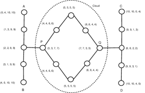
In virtual coordinate systems (VCS), it is desirable to minimize the onset of anomalies so that greedy forwarding works more frequently. The intuition behind some of the emerging VCS designs is that the uniqueness (measured in terms of percentage unique node labels) of the naming algorithm is positively related to the number of dimensions in a VCS. This intuition is based on an implicit assumption: the network is N-connected for an N-dimensional VCS and the uniqueness continues to increase as the number of dimensions increases. Figure 1 shows a network with a 4-dimensional VCS, by setting 4 anchor nodes at node A, B, C and D. The network is just 2-connected. And the highest degree of any vertex is only 3. In this case, the 4-dimensional VCS does not increase the naming uniqueness from a 2-dimensional VCS with anchor nodes as A and C (or B and D). The nodes in the middle Cloud can mostly find another node with the same identity, either in a 2-dimensional or 4-dimensional VCS, except the vertex cut nodes P and Q. Continuing to increase the number of dimensions of the VCS would not help the naming uniqueness, if the additional anchors locate outside the cloud. We call the highest number of VCS dimensions can be used to increase naming uniqueness the dimension; when this dimension is less than we refer to this phenomena as dimension degradation.
Definition 1
Given a graph , a component of it is a graph where , and .
Definition 2
A node cut (or a vertex cut) of a component is a set of nodes where removing will disconnect the rest of from or .
Definition 3
The connectivity of a graph is the minimum size node cut. A graph is -connected if its connectivity is at least .
Definition 4
A determinant component of a network with VCS, is a component of the mapping graph of this network, containing one or more VCS anchors. An indeterminate component is a component which is not determinant.
Definition 5
The virtual coordinate uniqueness degree of a VCS is the number of unique virtual coordinates of all nodes.
Definition 6
A dimensional degradation is the maximal number of dimensions of a network which can increase its .
For example, if the of a n-dimensional VCS on a network is , and the of a (n+1)-dimensional VCS is also , we say the of this network is .
Theorem III.1
The of a -connected graph is 1.
Proof:
Suppose a graph (of some network) is -connected, and the vertex cut is , where is an indeterminate component of and . In 1-dimensional virtual coordinate system, the virtual coordinate value of is . For , its network distance to is (in number of hops). We can directly infer the virtual coordinate value of is . We need to prove that if , then in 2-dimensional virtual coordinate system, . Since
If , then
∎
Lemma III.2
For any -connected graph , the .
Proof:
We use contradiction to prove. Suppose .
We may simply elect to be a new dimension anchor, then
Since the network distance
Contradict ∎
Theorem III.3
The of a complete graph , is .
Proof:
A complete graph is -connected. ∎
III-B Greedy Forwarding Failure: Lack of Naming Uniqueness
All routing failures of greedy forwarding on VCS including those in the previous section and our previous work [24, 23], are caused by some nodes with the same identity occurring in the network. For example, the Expanded VC Zone anomaly and the Disconnected VC Zone anomaly in a 3-dimensional VCS [24] arise because the graph of the network is 4-connected, which requires 4 or more anchors (dimensions) to be present the network to produce a virtual coordinate system with the maximal naming uniqueness. In some randomly deployed network, the graph may be 1-connected or 2-connected. Anomalies in such network’s VCS [23] is caused by dimensional degradation, which may be only 1 or 2. Increase the virtual coordinate dimensions does not increase the naming uniqueness. In a word, the anomalies in VCS are caused by either the limitation of dimensional degradation limiting the uniqueness, or dimensions does not reach the dimensional degradation – its number of anchors is not sufficient.
Although based on the Papadimitriou-Ratajczak conjecture [30], Rote and Bánány proved that a greedy embedding exists in any given 3-connected planar graph [33, 1]. In reality, a network with a 3-connected projected graph is not always available. A typical deployed network contains some nodes with degree 1, and many nodes with degree 2. Moreover, the required planarization may make it even the situation worse by removing links, leading to a planar graph with lower connectivity. Thus, increasing the number of anchors (dimensions) in VCS does not always make greedy forwarding always successful due to degraded dimensionality.
Finally, for a complete graph, without a -dimensional VCS, there will always be some nodes with same identity (virtual coordinates). But the -dimensional VCS is no better than shortest path routing which we want to avoid.
IV Spanning Path Virtual Coordinate System
In section III, we saw that the reason causing routing failure in VCS is the lack of naming uniqueness. In the worst case, the connectivity of a network’s mapping graph is 1. A consequent observation is that a VCS constructed only by the network distance (number of hops) to anchors can not provide naming uniqueness for general graphs. We propose here a new VCS naming approach, on which a stateless routing protocol can guarantee packet delivery. We call the VCS the Spanning-Path Virtual Coordinate System (SPVCS). In contrast to existing VCS, SPVCS assumes a connectivity no bigger than 1.
IV-A Spanning-Path VCS: Setup
A good routing protocol must set up on a good naming base, which should give each node an unique identity. Under the conservative assumption that a network is only 1-connected, we can not depend on increasing the number of anchors (or say, dimensions) of VCS as a way to provide this uniqueness.
The design of SPVCS is based on a depth-first search algorithm. A tree-style topology is constructed with only connection information. Any node can be chosen as the naming root. Value 0 is assigned to root node as its spanning-path virtual coordinate (SPVC). The root node would start the naming process by sending a depth-first search naming packet to one of its neighbor, serving as its naming child. On receiving a depth-first search naming packet, each node would be assigned an unique identity (name) incrementally to the SPVC value of its sender. The sender of this depth-first search naming packet is marked as the receiver’s parent. If a node has any neighbor that has not been assigned a SPVC, it would send a depth-first search naming packet to this neighbor. Otherwise, if all its neighbors are assigned a SPVC accordingly, it would decide that it is an end on the spanning-path, and sends an end-of-search naming packet to its parent, containing the maximal SPVC value of all its children. On receiving an end-of-search naming packet, a node would either send another depth-first search naming packet to one of its neighbors which has not been assigned a SPVC, with the replied SPVC value in the received end-of-search naming packet if applicable. Or if all its neighbors are assigned with SPVC, it would forward this end-of-search naming packet to its parent. This process would repeat until the root node receives an end-of-search naming packet and finds all of its neighbors are assigned some SPVC. As long as the network is connected, all nodes receive a unique identifier.
The pseudo-algorithm of SPVC naming process is summarized algorithm 1, where the is a recursive function used to set the spanning-path virtual coordinate values of , as algorithm 2.
IV-B Spanning-Path Geometric Routing
Based on the Spanning-Path Virtual Coordinate System (SPVCS), a stateless and delivery guaranteed geometric routing can be constructed. Suppose a node with SPVC value (referred as node X) needs to send a packet to another node with SPVC value (referred as node Y). It would mark each neighbor’s range as the neighbor’s SPVC value and its max-child SPVC value. A neighbor whose range contains the destination node’s SPVC value , is called a forwarding candidate. There are at most two forwarding candidates among the node’s neighbors, one of which is its parent. The non-parent forwarding candidate is preferred. This process would be repeated by any node receiving this packet, until node Y receives the packet. The algorithm can be summarized as algorithm 3.
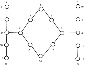
Spanning-Path Routing Example Let’s use the SPVC value of each node as its ID since this value is unique. In the figure 2, the node 5 needs to send a packet to node 14. In the VCS shown in figure 1, the greedy forwarding will fail since the source has the same identity as destination. In SPVCS, node 5 first check all its neighbors’ ranges: node 4’s range is (4, 15), node 6’s range is (6, 15). the destination SPVC is 14, so both neighbors are forwarding candidates. And node 4 is node 5’s parent, node 5 would forward the packet to node 6. Node 6 will repeat the process to forward packet to node 7. Node 7’s neighbors range are node 6 (6, 15), node 8 (8, 12) and node 13 (13, 15). Node 7 would forward packet to node 13. And finally, node 13 forwards packet to node 14.
As we can see, the spanning-path geometric routing is stateless and definitive: any forwarding node only needs the SPVCs of all its neighbors and the destination to make routing decision, without any repeat link on path.
Theorem IV.1
Spanning-Path Geometric Routing is delivery guaranteed, if the network is connected.
Proof:
Since is connected we have
where definitive reachable means no repeat link on path. And
∎
IV-C Optimized Spanning-Path VCS
The DFS based constructing procedure of Spanning-Path VCS leads to an un-balanced tree, shown as figure 3. Quite pathes constructed on Spanning-Path VCS need to go through the anchor node. A constructing procedure based on the breadth-first search (BFS) lead SPVCS to a balanced tree topology, shown in figure 4. The algorithm can be summarized as algorithm 4,
where the is shown as algorithm 5.
IV-D Aligned Greedy and Spanning-Path Routing (AGSP)
Since the spanning-path routing does not provide a greedy algorithm which shows a performance comparable to the optimal solution – the shortest path routing [23], to use SPR as complementary routing to greedy forwarding is rational. As we will show with experiment in section V, SPR collaborating with greedy forwarding will generate path with much better stretch. The routing algorithm of aligned greedy and spanning-path routing can be summarized as algorithm 6,
where the is to set up the aligned virtual coordinate system, on which the greedy forwarding can be used as .
V Experimental Evaluation
In this section, we present an experimental evaluation of the Spanning Path Virtual Coordinate System (SPVCS) in comparison to the complementary routing protocols in existing geometric protocols on physical coordinates (GeoCS) and virtual coordinates Systems (VCS). The evaluation tracks the average path stretch relative to SP. We also simulate AGSP, which uses aligned virtual coordinates, and switches to SPVCS when anomalies are encountered. We use a custom simulator written in C, to abstract away the details of the channel and networking protocols.
We study both random (uniform) and a custom “C” deployment. In the uniform scenarios, each node’s location is generated uniformly across the simulation area. For these scenarios, each point represents the average of 30 scenarios of 1000 nodes that are deployed unit area; in the custom scenarios, each points represents the average of 30 scenarios of 150 nodes deployed in a ”C” style area to create a physical void. In both cases, the number of scenarios was sufficient to tightly bound the confidence intervals. We simulate different densities by varying the radio transmission range. For every scenario, reach-ability is determined by testing packet delivery success between each pair of nodes in the network. Recall that the stateful SP provides optimal routing in terms of number of hops; for this reason it is used as the baseline for ideal performance in terms of path stretch.
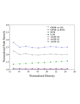
V-A Spanning-Path vs Perimeter Routing
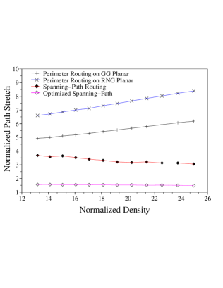
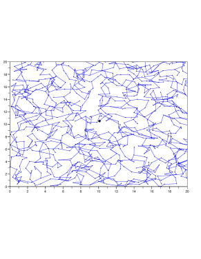
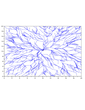
Figure 5 shows the path stretch of Perimeter routing (which is the complimentary routing protocol in GPSR) with different planarization algorithms. The figure also shows the performance of Spanning-Path Routing on SPVCS. As the density goes higher, Perimeter routing suffers; this is a known problem for perimeter routing, leading to an increased path stretch. However, Spanning-Path routing benefits from the denser network because it is based on connectivity instead of physical distance.
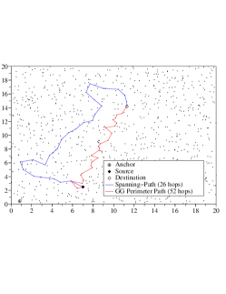
Figure 6 shows a comparison of sample paths constructed by Perimeter routing on GG Planar graph and Spanning-Path routing. Although the path constructed by Spanning-path routing is longer in distance length, it is much shorter in number of hops.
V-B Aligned Greedy Spanning-Path routing
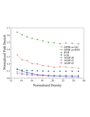
Figure 7 shows the path stretch obtained by different geometric routing protocols. As we can see, with some VCS alignment, AGSP (Aligned Greedy Spanning-Path) routing provides a competitive performance to that of GPSR, especially in sparse scenarios. Without alignment, greedy spanning-path routing suffers from the low greedy ratio due to the 4-d VCS naming failures.
V-C Custom Deployment
To study the protocols under more demanding conditions when uniform coverage does not exist, nodes are deployed uniformly in a C pattern, leaving a significant void area. Figure 8 shows the path stretch of Perimeter and Spanning-path routings in such scenarios scenario. As we can see, Spanning-path can tolerate such scenarios, while Perimeter routing suffers poor performance.
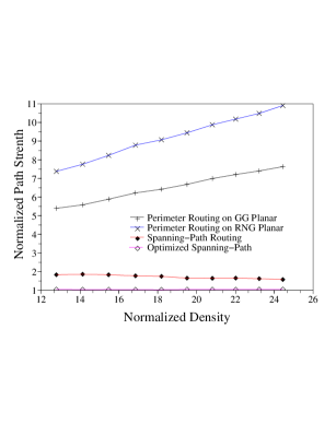
Also, AGSP shows a nearly optimal path stretch in such scenario compared to shortest path routing. Meanwhile, GPSR performance suffers since its greedy ratio drops dramatically due to the presence of voids on many paths. LCR shows a similar performance because its backtracking algorithm uses blind search of a limited number of neighbors.
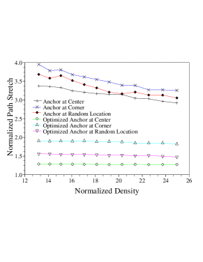
V-D The Impact of Anchor Location on SPVCS
Intuitively, anchor location has significant impact on the performance SPVCS. Experimental results support this intuition (Figure 10). An anchor node located near the center leads to the best path stretch since it can provide a more balanced spanning-tree. Conversely, an anchor at the corner results in worse performance with respect to path stretch.
V-E Optimizing SPVCS
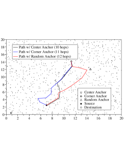
Figure 3 shows a sample SPVCS. The SPVCS algorithm leads to an unbalanced spanning tree of the network; clearly this is not the most efficient spanning topology. We seek to optimize this topology by replacing it with a balanced spanning tree, creating more effective paths, and limiting the impact of the anchor’s location. Sample paths are shown in Figure 11.
VI Conclusion
In this paper, we first analyze the reasons behind geometric routing failure in recently proposed VCS: dimensional degradation leading to the lack of uniqueness in naming. Practically, a unique identity can not be easily assigned to any node in VCS on network, due to limitation of network connectivity. This analysis represents a contrast to the common assumption of most those virtual coordinate systems – the more anchor nodes (virtual coordinate dimensions), the better the uniqueness and routability.
Consequently, we propose an alternative naming algorithm for virtual coordinate systems for geometric routing protocols, in which only one dimension (anchor) is used. We call this naming algorithm the Spanning-path Virtual Coordinate System. SPVCS provides unique numbers to all nodes in the network in a way that allows greedy routability (albeit with some path stretch since SPVCS does not use the full connectivity information).
Upon this SPVC assignment, a stateless and delivery guaranteed geometric routing protocol is constructed. We show that this protocol outperforms geographic routing (GPSR) [14], and several recently proposed geometric routing protocols on virtual coordinate systems such as LCR [3], BVR [7] and AVCS [23].
References
- [1] Imer Bárány and Güntor Rote. Strictly convex drawings of planar graphs. Documenta Mathmetica, 11:369–391, 2006.
- [2] Prosenjit Bose, Pat Morin, Ivan Stojmenovic, and Jorge Urrutia. Routing with guaranteed delivery in ad hoc wireless networks. In Proc. ACM DIALM’99, Seattle, WA, August 1999.
- [3] Qing Cao and Tarek F. Abdelzaher. LCR: A scalable logical coordinates framework for routing in wireless sensor networks. In RTSS, pages 349–358, 2004.
- [4] Antonio Caruso, Stefano Chessa, S. De, and A. Urpi. GPS free coordinate assignment and routing in wireless sensor networks. In INFOCOM, pages 150–160, 2005.
- [5] Q. Fang, J. Gao, and L. Guibas. Locating and bypassing routing holes in sensor networks. In Proceedings of INFOCOM’04, 2004.
- [6] Q. Fang, J. Gao, L. Guibas, V. de Silva, and L. Zhang. GLIDER: Gradient landmark-based distributed routing for sensor networks. In Proc. INFOCOM, 2005.
- [7] R. Fonseca, S. Ratnasamy, J. Zhao, C. Tien Ee, D. Culler, S. Shenker, and I. Stoica. Beacon vector routing: Scalable point-to-point routing in wireless sensornets. In Proc. of the 2nd Symposium on Networked Systems Design and Implementation (NSDI 2005), May 2005.
- [8] Sophia Fotopoulou-Prigipa and A. Bruce McDonald. GCRP: Geographic virtual circuit routing protocol for ad hoc networks. In Proceedings of MASS’04, 2004.
- [9] Hannes Frey and Ivan Stojmenovic. On delivery guarantees of face and combined greedy-face routing in ad hoc and sensor networks. In Proceedings of MobiCom’06, 2006.
- [10] A. Haeberlen, E. Flannery, A. M. Ladd, A. Rudys, D. S. Wallach, and L. E. Kavraki. Practical robust localization over large-scale 802.11 wireless networks. In Proceedings of MobiCom’02, 2002.
- [11] T. He, C. Huang, B. Blum, J. A. Stankovic, and T. Abdelzaher. Range-free localization schemes for large scale sensor networks. In Proc. of MobiCom 2003, 2003.
- [12] J. Hightower and G. Borriella. Location systems for ubiquitous computing. In IEEE Computer, volume 34, pages 57–66, 2001.
- [13] Qingfeng Huang, Chenyang Lu, and Gruia-Catalin Roman. Spatiotemporal multicast in sensor networks. In Proc. of the 1st international conference on Embedded networked sensor systems (Sensys’03), pages 205–217, 2003.
- [14] Brad Karp and H. T. Kung. GPSR: Greedy perimeter stateless routing for wireless networks. In Proc. 6th Annual International Conference on Mobile Computing and Networking (MobiCom 2000), 2000.
- [15] Young-Jin Kim, Ramesh Govindan, Brad Karp, and Scott Shenker. Geographic routing made practical. In Proceedings of the Second USENIX/ACM Symposium on Networked System Design and Implementation(NSDI’05), May 2005.
- [16] Fabian Kuhn, Roger Wattenhofer, Yan Zhang, and Aaron Zollinger. Geometric ad hoc routing: Of theory and practice. In Proceedings of PODC’03, 2003.
- [17] Fabian Kuhn, Roger Wattenhofer, and Aaron Zollinger. Worst-case optimal and average-case efficient geometric ad-hoc routing. In Proceedings of the 4th ACM International Symposium on Mobile Computing and Networking (MobiHoc 2003), 2003.
- [18] Jonathan Ledlie, Michael Mitzenmacher, Margo Seltzer, and Peter Pietzuch. Wired geometric routing. In Proceedings of IPTPS 2007, 2007.
- [19] Ben Leong. Phd. thesis: New techniques for geographic routing, 2006. MIT.
- [20] Ben Leong, Barbara Liskov, and Robert Morris. Greedy virtual coordinates for geographic routing. In Proceedings of ICNP’07, 2007.
- [21] Ben Leong, Sayan Mitra, , and Barbara Liskov. Path vector face routing: Geographic routing with local face information. In Proceedings of ICNP’05, 2005.
- [22] Cong Liu and Jie Wu. Destination-region-based local minimum aware geometric routing. In Proceedings of MASS’07, 2007.
- [23] Ke Liu and Nael Abu-Ghazaleh. Aligned virtual coordinates for greedy geometric routing in wireless sensor networks. In Proc. of 3rd IEEE international Conference on Mobile Ad-hoc and Sensor Networks (MASS) 2006, Oct. 2006.
- [24] Ke Liu and Nael Abu-Ghazaleh. Virtual coordinate backtracking for void traversal in geographic routing. In Procl. of 5th International Conference on AD-HOC Networks & Wireless (Ad hoc Now), August 2006.
- [25] T. Moscibroda, R. O’Dell, M. Wattenhofer, and R. Wattenhofer. Virtual coordinates for ad hoc and sensor networks. In Proceedings of ACM DIALM-POMC’04, October 2004.
- [26] R. Nagpal, H. Shrobe, and J. Bachrach. Organizing a global coordinate system from local information on an ad hoc sensor networks. In Proceedings of IPSN’03, 2003.
- [27] J. Newsome and D. Song. Gem: Graph embedding for routing and data-centric storage in sensor networks without geographic information. In Proceedings of SenSys’03, November 2003.
- [28] D. M. Nicol, M. E. Goldsby, and M. M. Johnson. Simulation analysis of virtual geographic routing. In Proceedings of the 2004 Winter Simulation Conference, 2004.
- [29] D. Niculescu and B. Nath. Ad hoc positioning system (APS). In The IEEE Global Telecommunications Conference (GLOBECOM, volume 5, pages 2926–2931, 2001.
- [30] C. H. Papadimitriou and D. Ratajczak. On a conjecture related to geometric routing. In Proceedings of ALGOSENSORS’04, 2004.
- [31] C. E. Perkins and E. M. Royer. Ad hoc on-demand distance vector routing. In Proceedings of the 2nd IEEE Workshop on Mobile Computing Systems and Applications, February 1999.
- [32] A. Rao, S. Ratnasamy, C. Papadimitriou, S. Shenker, and Ion Stoica. Geographic routing without location info. In Proceedings of MobiCom’03, 2003.
- [33] Güntor Rote. Strictly convex drawings of planar graphs. In SODA ’05: Proceedings of the Sixteenth Annual ACM-SIAM Symposium on Discrete Algorithms, pages 728–734, 2005.
- [34] K. Seada, A. Helmy, and R. Govindan. On the effect of localization errors on geographic face routing in sensor networks. In Proc. of IPSN’04, 2004.