Digging the topology of rock art in Northwestern Patagonia
Abstract
We present a study on the rock art of northern
Patagonia based on network analysis and communities detection. We unveil a significant
aggregation of archaeological sites, linked by common rock art motifs that
turn out to be consistent with their geographical distribution and
archaeological background of hunter-gatherer stages of regional peopling and land use.
This exploratory study will allow us to approach more accurately some
social strategies of visual communication entailed by
rock art motif distribution, in space and time.
Keywords: archaeology; complex networks; Patagonia; rock art; modularity
Published in Journal of Complex Networks, cmz033 (2019) https://doi.org/10.1093/comnet/cnz033.
1 Introduction
The use of analytical methods derived from network science has undeniably hatched over the last decade, bringing together several disciplines as mathematics, physics, computer science, biology and social sciences. Interdisciplinary approaches to the study of past and present societies, from the point of view of complex systems, have started to dominate the tendency towards the creation of knowledge in anthropology [1, 2, 3] and archaeology [4, 5, 6, 7, 8]. Within this context, the application of analytical methods derived from graph theory and from social network analysis to the study of archaeological problems has been increasing at a fast step. More examples of this interdisciplinary interaction can be found listed in [9] and [10], where the authors trace a thorough description of the state of the art of social network analysis and show its evolution within the last 50 years.
As stated in the review by Mills [7], the use of networks in archaeology is especially relevant for studies that look for relational patterns between the units or entities that compose the system under analysis. Their usefulness resides in the possibility of abstracting the most relevant features of a case study and represent them and their connections as a network [9, 11, 12]. In this way, the information can be analyzed globally and locally in a systematic manner by revealing the topological properties of the underlying network and the emerging patterns encoding valuable pieces of information. In fact, the structure associated to any cultural process is organized into networks of nodes and relational links that connect them. Once the abstraction exercise has been done, different networks can be constructed from the same archaeological data to explore different aspects of the same phenomena. One of the most relevant contributions of the application of complex networks in archaeology is its capacity to study large sets of archaeological data in different spatial scales and archaeological processes through time.
Within these premises, formal networks have been applied in different theoretical frames, to different archaeological contexts and also to a wide range of archaeological evidence. Such is the case of a recent work focusing on a site scale [13] that analyzes, from an entanglement perspective, how different materials are related in the clay use of Çatalhöyük (Anatolia). In a similar line, two very recent works [14, 15] applied social networks and community detection to analyze the formation of groups and social integration. In the former, the authors also analyze the Çatalhöyük site, and study a vast set of archaeological data to find the dynamics of interconnectivity and cooperation among different settlements. In the latter, obsidian artifacts of northern New Zealand, to trace social affiliation of Māori people during a time of social changes.
Another significant approach is the one oriented to solve problems related to procurement, distribution and use of raw materials, like obsidian and pottery compositions [8, 16, 17]. From a macroregional approach, a wide variety of works can be found in Knappett’s compilation [5]. Currently, a prominent work in this line of macroregional approaches is that of Radivojevic and Grujic [12] who, by means of community detection applied to a chemical data of copper-based objects, identify a significant community network of metal production and exchange during 3000 years in East-Central Europe.
Also, within this increasing context of network analysis in archaeology, there are studies that discuss the methodological and even the epistemological challenges of the application of networks in the archaeological field [8, 9, 18].
The application of formal network analysis in rock art studies do not have a long tradition and, in the literature, we found only a few cases [11, 19, 20]. The pioneering work of Alexander [19] applied for the first time analytical methods to the study of a single panel of the rock art site known as the Bedolina Map, in Valcamonica (Italy). His goal was to shed light on the structural composition of the complex motif. Another relevant work is that of Caridi and Scheinsohn [11], who built a mutual information network from a set of data of western Patagonian rock art, to the south of our study region. Their goal was to model possible paths of cultural and information transmission by means of rock art motifs, by identifying clusters of associated sites. Their results show five clusters with a strong overlapping, interpreted as different moments of cultural transmission paths. Finally, a recent paper by Riris and Oliver [20] applies network analysis to a data set of rock art in the Orinoco basin (Venezuela), to analyze the possible links or discontinuities within a set of sites in terms of stylistic attributes.
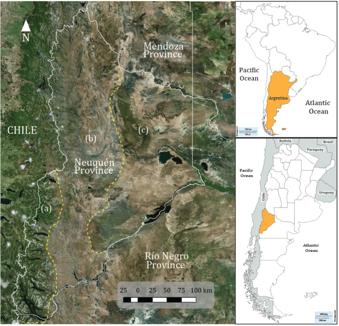
The present work is focused on the study and characterization of a set of rock art sites by means of network analysis. The region of study is located in the provinces of Neuquén and Río Negro (Argentina) [21] (Fig. 1). A previous version of this work was presented at the Archaeology Congress of Patagonia [22] and is part of a larger project that aims to discuss the flow of information and mechanisms of cultural transmission in relation to archaeological hunter-gatherer models in northern Patagonia. We applied a novel analysis for rock art studies, based on communities detection, to solve some basic questions about the structure of the selected data and their spatial distribution. It is a first step towards the elucidation of the possible ways in which information and visual codes flowed in the past, and also to show how this gave place to the specific distribution of the set over the landscape [23]. A similar approach has been useful to model the geographical path of information, including but exceeding their topological dimension, which helped to reconstruct ancient hunter-gatherer paths, territories, action ranges, and other archaeological implications [24]. In turn, this information will serve as a comparative parameter to be contrasted with an archaeological model of land occupation and use of space in future research projects.
Our goal is to carry out an exploratory analysis at two different levels, drawn on shared features at each of the surveyed sites. Firstly, we evaluate the existence of correlations between the geographical distribution of the sites and the prevalence of different rock art motifs among them. Secondly, we perform a similar analysis but centered on the motifs themselves, in order to analyze the existence of well-defined ensembles of motifs. Based on the topological properties we intend to: a) detect the existence of highly relevant nodes, b) record how the nodes are organized, and c) check for the existence of communities by a modularity analysis. By means of such analysis we aim to unveil a meaningful aggregation of sites, linked by common cultural features that turns to be consistent with the possibility of cultural transmission or territorial behavior backed up by their geographical distribution.
At the same time that we presented the preliminary results of our analysis of community detection [22], a novel and significant article was published (Ref. [12], mentioned above), also applying this methodology but to a very different archaeological context. In their work, the authors evaluate the organization and interactions of copper using societies in the Balkans, from c. 6200 to c. 3200 BC, by means of a community structure analysis of the underlying network connecting several archaeological sites. The links among nodes were traced through the use of chemical data of copper-based objects. The resulting division into communities revealed three dominant modular structures across the entire period, with strong spatial and temporal significance. Later, during the review process of the present work, an additional paper appeared, applying the same methodology of community detection [14], also cited above.
It is also worth mentioning that some of the sites studied here have been already analyzed in [11], where the authors aim at tracking cultural transmission paths by means of motif distribution in those sites. The analysis of the constructed mutual information network between motifs allowed the authors to propose a certain geographical organization with the presence of a hub region and satellite sites. The collection of sites presented here is larger, and the methodology is different as well.
1.1 Archaeological background of northwestern Patagonia
Rock art is one of the most abundant and relatively unknown archaeological evidence in our study region in northwestern Patagonia. These manifestations, either paintings or engravings on the rocks, constitute evidence of the communicative and symbolic dimension of the hunter-gatherer groups that inhabited this region. Rock art images occupied a central and active role in the transmission of information and knowledge for the immediate participants and also for their descendents.
In particular, the actual region of Neuquén and the northwestern Río Negro provinces, stands out for having a large number of sites with paintings and rock engravings, which are distributed in three different environments: the steppe, the ecotone and the forest (see Figure 2). It has been established that they proliferated fundamentally during the last 3000 years, increasing both in number and in diversity of designs. This increase occurred in a context of demographic growth and possibly spatial or territorial circumscription of the hunter-gatherer groups that inhabited these environments [11, 25, 26]. In this sense, one of the most relevant characteristics of rock art in our study region is that, on a wide scale but also in short distances, there are different environments with an extensive set of rock art sites which have, in turn, differences in their visual and technical features.
In the case of the steppe, more than 50 archaeological sites have been identified and studied with the presence of both paintings and engravings [25, 27, 28]. Historically these sites were studied by traditional methods of stylistic classification within a normative culture-history framework [29]. In addition to this diffusionist explanation of social processes, these styles were used as chronological indicators to date other artwork. One of the most criticized aspects of these chronological styles was their lack of an explicit definition of the methodology used to formulate them, either qualitative or quantitative. Besides, there was also a lack of interest in studying the spatiality of rock art and its distribution over a large scale, as we are proposing here. In this way the styles were arbitrarily defined from the association, sometimes ambiguous and sometimes exclusive and rigid, of sets of motifs [30].
In synthetic terms, in our wide region of study three great rock styles were defined, the footprint style (estilo de pisadas) [31], the fret style (estilo de grecas) [31], also called Complex and Geometric-Abstract Trend (TAGC) [32], and the parallels style (estilo de paralelas) [31, 33, 34]. The temporal duration of these styles is not precise, because there is not direct dating of rock art. It has been possible, nevertheless, by dating archaeological layers covering some rock art motifs, to distinguish temporal blocks for the different repertoires of Patagonian rock art [31, 32, 35]. In the case of northwestern Patagonia, the footprint style has been indirectly dated with an estimated antiquity of about 3000 years BP [25], and was characterized by the representation of animals and humans through their footsteps or footprints, in conjunction with simple geometric designs such as circles, lines and points.
In the case of the fret style or TAGC, it was defined as containing designs of considerable geometric complexity like labyrinths, staircase and crenellated motifs, a wide diversity of frets, crosses, squares and also framed and schematic human representations. At present, this style constitutes a challenge for archaeologists, since a great diversity of designs coexist within it, and there is no consensus about its extension in time and space. It is estimated, by indirect dating and the similarity of designs on artifacts found in archaeological stratigraphy, that the age of this style does not exceed 1000 years BP [25, 36, 37].
In turn, the case of the parallels style has a different context, because in the archaeological literature it appears to be one of the unique and solitaire styles of the extreme north of the Neuquén province. Its age, also by no direct means, has been estimated in no more than 600 years BP [34].
In the ecotone and forest environments the rock art sites are located mainly near large bodies of water (Figure 2). One of the peculiarities of these sites is that they contain entirely rock paintings, and their repertoire of designs differ markedly from the shapes of the neighboring steppe. In particular, there are designs that represent quadruped animals like huemuls (Hippocamelus bisulcus) and guanacos (Lama guanicoe), and also human figures that in many cases are represented with quadruped animals (interpreted as mounted horses). These characteristics have allowed archaeologists to postulate that this repertoire of motifs belongs to a more recent and different modality within the fret style, called the Modality of the Forest and Lake Area or MABL [36]. Archaeologists argue that these paintings were made by a group substantially different from those of the steppe, that ethno-historic sources identified as an ethnic group called Puelches, which were fully adapted to this lacustrine-forested environment, since they dominated the use of boats and navigation [38].
As can be seen, the presence of a large number and variety of rock art sites located in the different environments of Neuquén and the northwest of the Río Negro provinces, constitutes the evidence that diverse groups, during at least the last 3000 years, displayed substantially different visual, communicative and significant strategies.
2 Database and network construction
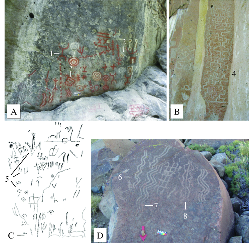
The database of prehistoric rock art consists of georeferenced sites, each of which contains paintings, engravings or both [22]. This relational database includes both published information about rock art sites from Patagonia as well as fieldwork data provided by our own team members and ARPat database [22, 26, 39]. It contains information at the site scale and at the motif scale, which can be used independently or combined, according to digital queries defined by archaeological research questions. Out of this macro-regional database, we have selected for this paper 136 sites which regionally fall within Northwestern Patagonia. The quantity of motifs at each site ranges from 1 to 35 (with a mode of 7 motifs), totalizing 1095 motifs [21]. Examples are shown in Fig. 2. Given the large variety of motifs designs, we classified them into groups, according to their geometric and morphology and also in terms of figurative an nonfigurative designs. This led to the definition of a total of 148 motif groups (see Appendix II). Examples of the groups are: concentric circles, parallel lines, feline tracks, frets, etc., some of which can be seen in Fig. 2.
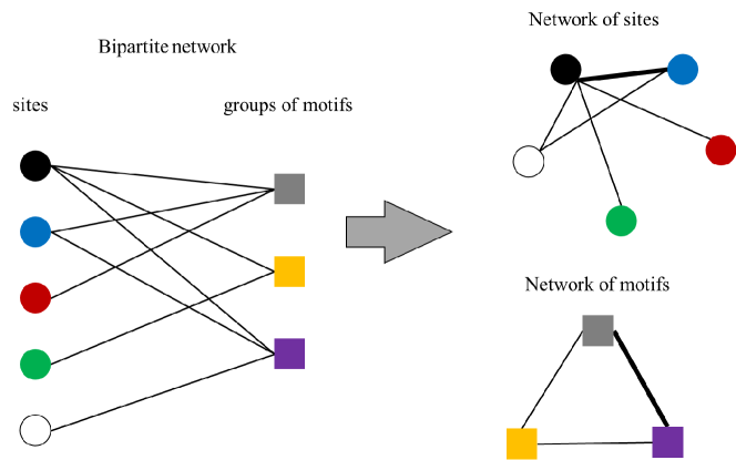
The information about each site and the corresponding groups of motifs present in them was used to construct a bipartite network with sites and groups of motifs on each side, as follows: a group of motifs is linked to a site if any of the motifs that belongs to the group is present at the site. From this bipartite network we built two different projections, with their nodes identified with only one of the two parts in each case. An example of the procedure is presented in Fig. 3. In this way we obtained the following two network types:
Network of sites. In this case the nodes of the network are the archaeological sites. Two nodes are connected by a link if they share at least one group of motifs in common. If more than one group is shared, the link is weighted accordingly. It is important to note that the network thus constructed is an artificial mathematical object, which does not (necessarily) correspond to actual connections between the people that populated the sites and produced the art. This network is even blind with respect to the geographical location of the sites. Any topological structure present in the network will emerge from the complex sharing of groups of motifs between them.
Network of motifs. In this case the nodes are the categories to which each motif design corresponds, which as noted above, are called motif groups. Two nodes of this network are linked if the corresponding motif groups appear at the same site. If a pair of groups appear together in more than one site, the link is weighted accordingly. This motifs network is complementary to the network of sites, and provides an insight on the possible relationships between the many motif categories of the set, thus shedding light on their stylistic classification.
These two types of networks were analyzed using standard tools of the theory of complex networks, in order to characterize their topological properties. Of particular interest in this study is the analysis of the partitions of the set of nodes, which define what are called communities of the network. Social networks, built on contact between people, naturally break into communities that the mathematical analysis can detect. Bear in mind, however that our networks are not based on any known contact between people, but just by sharing common material culture elements instead.
3 Results
| Network | |||||||
|---|---|---|---|---|---|---|---|
| of sites | 136 | 0.51 | 1.75 | 68.2 | 0.72 | 0.77 | 49.8 |
| of motifs | 148 | 0.13 | 2.33 | 19.6 | 0.37 | 0.58 | 91.4 |
Quantitative properties of the networks are summarized in Table 1. It is noticeable that the network of sites is rather dense, with a density of of all possible links. The average degree of sites is also large at , from a distribution that, ranging from 1 to 119, is biased towards large values. We also see that the average path length of both networks is small, and that both are highly clustered. The higher clustering of the network of sites makes sense in the context of the spatial unity and cultural homogeneity (see Discussion).
The most interesting results are provided by the modularity analysis of both networks. This was done using two algorithms that support weighted graphs and that have proven to be adequate to this kind of social network [42]. The algorithm based on the leading eigenvector of the community matrix [43], as well as the Louvain method [44] were used. The resulting communities of the network of sites are shown in Fig. 4 (and listed in Appendix I), with the sites at their geographical location (which does not play any role in the calculation). The two algorithms give very similar results, with a small but relevant difference. The leading eigenvector method finds three communities of similar size (Fig. 4, left). These will be referred to according to their geographical range: North of Neuquén (black), Forest (green) and Steppe (red). It can be seen that, apart from a few sites between latitudes and , the North of Neuquén community is the most geographically segregated of the three, occupying mainly the namesake region. The other two communities occupy mostly the whole range of the area under study, from the Andes mountain range on the west and over the Patagonian steppe at the center and east. The Steppe community, though, stays mainly east of the Andes.
The Louvain algorithm finds four communities (Fig. 4, right), with the overwhelming difference being the split of the Forest community found by leading eigenvector into two: a Nahuel Huapi community (green, concentrated around the southernmost tip of Neuquén, and corresponding to the Nahuel Huapi lake region), and a Valleys community (blue), extending along several river valleys in the transition region between forest and steppe. The size of the symbols in Fig. 4 corresponds to the betweenness centrality of the sites, . We can see that the Valleys community is dominated by the sites with largest values of of the Forest community found by the leading eigenvector method.
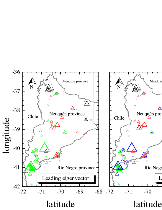
Figure 4 is one of the main results of this paper. It is remarkable that these three (or four) homogeneous sets of sites are well segregated in geographical space, even though the analysis, as mentioned, contains no information on the location of the sites. They show the potential existence of homogeneous blocks, with shared coherent information and visual codes, belonging to each one of this (mathematical) communities, which are based on a stylistic similarity given just by sharing groups of motifs. Indeed, the regions occupied by North of Neuquén province, Nahuel Huapi, Valleys and Steppe were inhabited by hunter-gatherer groups, which gradually occupied the environments in a discontinuous way during the last 4000 years. In this sense the network communities, despite not pondering the temporal variable of the data set, are coherent with some archaeological inferences about the occupation of the environments of northern Patagonia (see Discussion below).
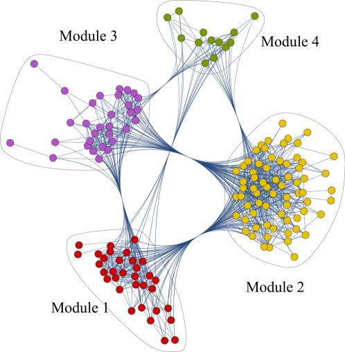
We also analyzed the modularity structure of the network of groups of motifs. In this case, the communities indicate the existence of ensembles of motifs that tend to appear together, akin to stylistic modalities. In the following we will use the term “module” to refer to these communities of groups of motifs, especially to distinguish them from the “communities” of the network of sites. Again, bear in mind that the analysis is completely blind with respect to any other information about the system. The modules found by the two algorithms are listed in corresponding tables in Appendix II. It is difficult to represent them on a map, because more than one thousand motifs are restricted to 136 sites. Figure 5 is an attempt to do so. Each symbol is colored according to its module, and their size reflects the number of motifs of the corresponding group present at the site.
In this case, the leading eigenvector algorithm shows the existence of 2 modules (2 disconnected nodes, fig H and fig rhombus, were left out of the analysis). It is easy to see that these modules, just like the communities found in the network of sites, are also segregated in space. There is a Module 1 (red), typical of the North of Neuquén, and a Module 2 (orange), typical of the South. Both of them mix, even at single sites, in the central valleys and steppe regions. The Louvain method again identifies subsets of the southern community. In this case the Module 2 of the leading eigenvector algorithm is split in three. The community structure is shown in Fig. 6. Two of them (Modules 3 and 4, purple and green respectively) are smaller, and found mainly in the mixing regions of the steppe. We will discuss this structure and its relevance in the following section.
4 Discussion
Results are discussed here in the context of the actual system that the two identified networks represent. The modularity analysis carried out on the graphs has no information about the cultural, historical or geographical background of the sites and their motifs content. The resulting communities could have been just mathematical artifacts, devoid of anthropological meaning. However, we have found that both the sites network’s communities and the motifs network’s modules are full of relevant information. On the one hand, we see a clear distribution of the communities of sites over the landscape. On the other, the network of motifs allows us to start discussing not only their composition according to the classical styles classifications, but also a different configuration of those archaeological constructs.
Starting with the geographical distribution of the sites’ communities, three (or four) distinct communities have been found: North of Neuquén, Forest (or Nahuel Huapi plus Valleys) and Steppe. These are easily recognizable as significant archaeological units. In the case of north of Neuquén, recently it has been shown by rock art and archaeological research [28], that the human groups that inhabited the North of Neuquén province participated actively in a regional dynamic of mobility and interaction together with the Maule region in Chile, at least during the last 1000 years BP [28, 34, 41, 45]. Our modularity analysis was able to detect the context of production and use of rock art images that reinforces the particular identity of archaeological signals of the north of Neuquén apart from the rest of the province. Besides, the result of the motifs community analysis also shows an important presence of motifs that, under a classical framework, would be interpreted as belonging to the footsteps style (Apendix II, Louvain Module 1). As a consequence, the modularity analysis allows us to visualize a greater variability of motives than expected in the north of Neuquén, starting to reconfigure the status and distribution of the classical “parallels style.”
As we briefly mentioned above, the human occupation of the ecotone and the steppe differs from that of the Andean forests, since it has more evidence of early human presence [46, 47, 48, 49, 50, 51, 52, 53] without the discontinuities observed in the forest environment and specifically in the Nahuel Huapi area [41]. The human groups that inhabited the ecotone and the steppe centered their economy and subsistence on guanaco (Lama guanicoe) hunting, complemented sporadically with resources from the forest [54]. It is also an extremely different habitat, desertic except in the rivers’ valleys. In this case, the steppe environment, as well as the north of Neuquén, were mostly identified as the same communities by both algorithms (leading eigenvector and Louvain). Nevertheless, the results of the analysis show a clear distribution of one large community of sites, along the wide space of steppe, extending from north to south. The motifs of these sites are dominated by animal and human footprints with simple geometrical motifs, which is coherent with the archaeological background that postulates a minimum age of this rock art in 3000 years BP, produced with a particular engraving technique [25]. However, although it contains many geometrical patterns (such as frets), they are very different from the similar geometrical patterns found in forests. Again, our analysis was able to identify the steppe as one of the unique communities with a great diversity of motifs, mixing the classical footstep style with the motif commonly adscribed to the fret style.
The case of the Forest community (leading eigenvector) deserves special attention, since it was split by Louvain into two communities (Nahuel Huapi and Valleys): this has archaeological implications. From a biogeographic perspective, the southern half of Neuquén has a phytogeographic transition: the ecotone between the Patagonian forest and the steppe. It was revealed by the Louvain method that it has differences in the communities of sites and motifs, as if it were a transitional region. As mentioned, previous archaeological approaches to rock art have proposed that the forest and lake environments of southern Neuquén and the west of the provinces of Río Negro (especially from the Manso river to the Nahuel Huapi and Lacar lakes) possess only one and unique style: the style of frets, called Modality of the Forest and Lake Area [36, 38]. This style was related to hunter-gatherer groups with aquatic mobility, well adapted to lacustrian environments, and it has been used as an archaeological indicator to mark the differences with hunter-gatherer groups with only pedestrian mobility that inhabited the ecotone and the neighboring steppe [38].
Even if the fret style is ubiquitous in both environments, there are several differences in terms of the morphology, techniques and colors of their composing motifs. In the former case, the basin of Manso river, Nahuel Huapi and Lacar lakes, fret style motifs are usually monochromatic red and mostly made with painting techniques [36, 37, 38, 55]. There is a transition to polychromy in the valley of the Traful river [56, 57] and also the Meliquina river and lake, near the ecotone environment, and they are definite polychromous in the steppe [58]. This difference could be explained not only from a point of view of the availability of raw materials, because the Nahuel Huapi sites are relatively close to the steppe where raw materials to make colors are available, but also as an intentional cultural choice with the purpose of marking the landscape differently. It is remarkable that, even though all this cultural and rock art information was not loaded into the database used to build the networks, the modularity analysis was able to detect these subtle differences and find these two (sub-)communities.
Another interesting result of the split into two communities of the southern half of Neuquén is the presence of nodes (sites) with large betweenness centrality (the size of the symbols in Fig. 4), which also has possible archaeological implications. In particular, the Huechahue site has the highest centrality and it is located precisely at the ecotone region in one of the valleys that connects the Andes with the steppe. As we saw, this is both a biogeographic transition and a boundary between site communities. This high centrality measure of the Huechahue site could be a consequence not only of its geographically strategical position but also of its probable role as an aggregation site, or a place where hunter-gatherer sub-groups met at specific times of the year (e.g. seasonally, annually, etc.).
Regarding the network of motifs, the modularity analysis also produced relevant communities that can be identified as a set of coherent information on spaces where the information circulated in a relatively standardized way. This automatic procedure gives independent support to analyze modalities, and proposes the possible existence of different ones within the fret style, about which there is an ongoing controversy [30, 35]. In this case, we were able to distinguish qualitatively and quantitatively the differences expressed between the motifs found in the forest and those belonging to the ecotone and steppe environment. In the case of the first (see Appendix II), we verified that the presence of anthropomorphs and zoomorphs is a clear signal that characterizes the forest’s rock art. In addition, Module 2 presented more variety of geometrical motifs than expected for its environment, because the stylistic modality of the forest was defined as consisting predominantly of figurative motifs [41]. This allows us to attempt a redefinition of the repertoire of motifs belonging to the traditional Modality of the Forest and Lake Area. However, it should be noted that this difference may also be due to a sample bias, not only because we focused on the western side of Neuquén province, but also because the forest environment has better records and more publications of archaeological sites. On the latter (see Appendix II, Modules 3 and 4), we identified and verified that the fret motifs are more varied and complex, as well as accompanied by simple geometric and figurative motifs. This implies a greater diversity, possibly due to the differences observed in terms of the history of human occupation of the steppe and the ecotone during the last 3000 years BP.
In summary, our community detection analysis shows a clear differentiation of networks of sites with no overlapping between them and distributed over three different environments. This scenario can be interpreted as a possible stage during the late Holocene where different groups were marking and using each landscape in a different way. However, taking into account that in the database we have integrated and analyzed sites covering a temporal range of about 3000 years, these networks that we observe distributed in space could be the product of different groups marking the landscape in different periods of time. So, there is a possibility that we were seeing transient networks. Nevertheless, we think that the analysis is robust because, despite of the temporal problem, we were able to detect just three or four networks, either by the Louvain or leading eigenvector algorithms. In a synthetic way, it is clear from independent evidence that the steppe environment, including the north of Neuquén, are more connected to each other than between them and the sites of the ecotone and forest environments, which in turn split in at least two more communities. All these networks are compatible with the archaeological background in terms of the human groups that inhabited these diverse environment, and also with the expectation from the possible demographic density in a human occupation scenario of these spaces.
In order to test the significance of our findings regarding the community structure of the networks, we have randomized the original networks according to the following procedure. We chose two pairs of connected nodes and interchange their links, avoiding double links and loops. The repeated application of this procedure randomizes the network preserving the degree of each node. By controlling the number of such changes, we can control the randomization introduced in the original network. We have observed that the modularity of these networks decreases with the randomization and, correspondingly, the number of communities increases. Also that their community structure lacks any relevant information content from an anthropological point of view, since the links are progressively randomized. The results of our analysis, instead, can be framed in the existing body of archaeological knowledge, as discussed.
5 Conclusion
The application of network analysis to the rock art database of northern Patagonia brings new insight in two important ways. Firstly, we want to highlight the methodological aspect of community detection as a formal method to identify possible anthropological and archaeological processes at different spatial scales [12, 14]. This methodological innovation allows us to visualize and discriminate clusters of sites and motifs in a suprarregional scale, which is not a common approach in rock art studies of Patagonia.
The detection of communities in rock art studies could serve as a first step to discover in which manner the repertoire of sites and motifs are distributed and linked through the landscape, and which sites could have particular properties or roles within the network. In our case, the communities were coherent with the archaeological background of hunter-gatherers of northern Patagonia. This type of analysis will allow us to generate hypotheses about the relevance of certain sites or sets of sites within the network, to be contrasted with other lines of evidence and archaeological models of land use, mobility and subsistence.
Finally, the most challenging and promising issue that network analysis of rock art can provide is the detection of the variability of the rock art record, which cannot be visualized or identified with traditional archaeological methods. Such is the case of those sites or group of sites which do not fit into the regional styles or repertoires previously established and with traditional consensus in the academic arena. As was mentioned by Taçon [59], we need to pay attention to those sites that are in between two or more well-known regional styles, in order to achieve a more accurate interpretation on their role in past hunter-gatherer systems. The relational approach of network analysis and specifically of community detection is a fruitful path to explore, as well as their implication into regional archaeological debates.
Funding
This work was supported by Agencia Nacional de Promoción Científica y Tecnológica [PICT-2014-1558]; Universidad Nacional de Cuyo [06/506].
Acknowledgements
F.E.V. acknowledges CONICET for the partial support of this research through a doctoral fellowship.
References
- [1] Hamilton, MJ, Milne, BT, Walker, RS, Burger, O, Brown, JH (2007). The complex structure of hunter-gatherer social networks, Proc. R. Soc. B: Biological Sciences 274, 2195-2203.
- [2] Apicella, CL, Marlowe, FW, Fowler, JH and Christakis, NA (2012). Social networks and cooperation in hunter-gatherers, Nature 481, 497.
- [3] Migliano, AB, Page, AE, Gómez-Gardeñes, J, Salali, GD, Viguier, S, Dyble, Mark, Thompson, J, Chaudhary, Nikhill, Smith, D, Strods, J and others, (2017). Characterization of hunter-gatherer networks and implications for cumulative culture, Nature Human Behaviour 1, 0043.
- [4] Kohler, TA (2012). Complex systems and archaeology, Archaeological Theory Today 93-123.
- [5] Knappett, C (2013). Network analysis in archaeology: New approaches to regional interaction, (Oxford University Press, Oxford).
- [6] Brughmans, T, Collar, A and Coward, F (2016). The connected past: challenges to network studies in archaeology and history, (Oxford University Press, Oxford).
- [7] Mills, BJ (2017). Social Network Analysis in Archaeology. Annu. Rev. Anthropol. 46, 379-97.
- [8] Gjesfjeld, E (2015). Network Analysis of archaeological data from Hunter-Gatherers: methodological problems and potential solutions, J. Arch Method and Theory 22, 182-205.
- [9] Collar, A, Coward, F, Brughmans, T and Mills, BJ (2015). Networks in Archaeology: Phenomena, Abstraction, Representation. J. Archaeolog. Meth. Theor. 22, 1-32.
- [10] Brughmans, T (2013). Thinking through networks: a review of formal network methods in archaeology. J. Arch. Method and Theory, 20, 623-662.
- [11] Caridi I and Scheinsohn V (2016). Mind the Network: Rock Art, Cultural Transmission, and Mutual Information. In: Mendoza Straffon L (Ed.), Cultural Phylogenetics, pp. 161-170, (Springer, New York).
- [12] Radivojević M and Grujić, J (2018). Community structure of copper supply networks in the prehistoric Balkans: An independent evaluation of the archaeological record from the 7th to the 4th millennium BC. J. Comp. Networks 6, 106-124.
- [13] Hodder, I and Mol, A (2016). Network analysis and entanglement, Journal of archaeological method and theory 23(4), 1066-1094.
- [14] Mazzucato, C (2019). Socio-material Archaeological Networks at Çatalhöyük a Community Detection Approach, Frontiers in Digital Humanities 6, 8.
- [15] Ladefoged, TN, Gemmell, C, McCoy, M, Jorgensen, A, Glover, H, Stevenson, C and O Neale, D (2019). Social network analysis of obsidian artefacts and Maori interaction in northern Aotearoa New Zealand, PloS ONE 14(3), e0212941.
- [16] Golitko, M and Feinman, GM (2015). Procurement and distribution of pre-Hispanic Mesoamerican obsidian 900 BC–AD 1520: A social network analysis, Journal of Archaeological Method and Theory 22, 206-247.
- [17] Gjesfjeld, E and Phillips, SC (2013). Evaluating adaptive network strategies with geochemical sourcing data: a case study from the Kuril Islands, In: Knappett, C, Network analysis in archaeology: New approaches to regional interaction, pp. 281-305 (Oxford Scholarship Online).
- [18] Peeples, MA and Roberts Jr, JM (2013). To binarize or not to binarize: relational data and the construction of archaeological networks, J. Arch. Sci 40, 3001-3010.
- [19] Alexander, C (2008). The Bedolina Map – an Exploratory Network Analysis. In: Posluschny, A, Lambers K and Herzog I (Eds.), Layers of Perception. Proceedings of the 35th International Conference on Computer Applications and Quantitative Methods in Archaeology, pp. 366-371 (Dr. Rudolf Habelt GmbH, Bonn).
- [20] Riris, P and Oliver, J (2019). Patterns of Style, Diversity, and Similarity in Middle Orinoco Rock Art Assemblages, Arts 8(2), 48.
- [21] Vargas, FE Spaces, images and visual rock communication through time, Neuquén, Patagonia, Argentina, Ph. D. thesis (University of Buenos Aires, Argentina, in preparation).
- [22] Vargas, FE, Lanata, JL, Fiore, D, Abramson, G and Kuperman, MN (2017). ¿Topologías Rupestres? Tramas visuales e información desde un análisis exploratorio de redes. X Jornadas de Arqueología de la Patagonia, Libro de Resúmenes, Julieta Gómez Otero et al. (Eds.), compiled by por Julieta Gómez Otero, Instituto de Diversidad y Evolución Austral, Puerto Madryn, Argentina.
- [23] Whallon, R, Lovis WA and Hitchcock RK (2011). Information and Its Role in Hunter-Gatherer Bands (Costen Institute of Archaeology Press, Los Angeles).
- [24] Scheinsohn, V (2011). Rock Art Information among Hunter-Gatherers in Northwest Patagonia: An Assessment of Environmental and Territorial Models. In: Whallon, R, Lovis WA and Hitchcock K (Eds.), Information and its role in hunter-gatherer bands, pp.235-248. (Costen Institute of Archaeology Press, Los Angeles).
- [25] Crivelli, E (2006). Frecuencia de creación de sitio de arte rupestre en la cuenca media y superior del río Limay (noroeste patagónico). In: Fiore, D and Podestá, MM (Eds.), Tramas en la piedra. Producción y usos del arte rupestre, pp. 63-74, World Archaeological Congress (WAC), SAA, Asociación de Amigos del Instituto Nacional de Antropología, Buenos Aires.
- [26] Fiore, D (2006). Poblamiento de imágenes: arte rupestre y colonización de la Patagonia. Variabilidad y ritmos de cambio en el tiempo y espacio. In: Fiore D and Podestá MM (Eds.), Tramas en la Piedra. Producción y usos del arte rupestre, pp.43-61. WAC, SAA, Asociación de Amigos del Instituto Nacional de Antropología, Buenos Aires.
- [27] Boschin, MT (2009). Tierra de hechiceros arte indígena de Patagonia Septentrional Argentina, (Universidad de Salamanca, Salamanca).
- [28] Vargas, FE (2019). Rock images and archaeological models: Towards a contextualization of the petroglyphs in the Curi-Leuvú basin (North of Neuquén, Argentine Patagonia), Chungara (in press).
- [29] Sanz ID, Fiore D (2014). Style: Its Role in the Archaeology of Art. In: Smith C (Ed.) Encyclopedia of Global Archaeology (Springer, New York, NY).
- [30] Scheinsohn, V and Caridi, I (2016). En busca del estilo de grecas. In: Oliva, F, Rocchietti, AM, Solomita Banfi, F (Eds.), Imágenes rupestres, lugares y regiones, p. 407 (Rosario, Argentina).
- [31] Menghin, O (1957). Estilos de arte rupestre de Patagonia, Acta præhistorica 1, 57-87.
- [32] Gradin, C (1999). Sobre las tendencias del arte rupestre de la Patagonia Argentina. In: Tamagnini M and Rochietti A (Eds.), Segundas Jornadas de Investigaciones de Investigadores en Arqueología y Etnohistoria del Centro-Oeste del País, pp. 87-99. (Universidad Nacional de Río Cuarto, Río Cuarto).
- [33] Schobinger, J. S. (1956). El arte rupestre de la Provincia del Neuquén. Anales de Arqueología y Etnología XXII: 115-227.
- [34] Fernández, J (2000). Las piedras con marcas de la cordillera del Viento. Arte rupestre en el departamento Minas, Neuquén, Argentina (SAA, Buenos Aires).
- [35] Boschín, MT, Fernández, M and Arrigoni, G (2016). ¿A qué aludimos cuando nos referimos al estilo de grecas en Patagonia?. In: Oliva, F, Rocchietti, AM, Solomita Banfi, F (Eds.), Imágenes rupestres, lugares y regiones, p. XX (Rosario, Argentina).
- [36] Albornoz, AM and Cuneo, E (2000). Análisis comparativo de sitios con pictografías en ambientes lacustres boscosos de Patagonia Septentrional. In: Arte en las Rocas. Arte rupestre, Menhires y piedras de colores en la Argentina, pp. 163-174 (Sociedad Argentina de Antropología, Asociación de Amigos del INA, Buenos Aires).
- [37] Podestá, MM, Bellelli, C, Labarca, R, Albornoz, AM, Vasini, A and Tropea, E (2008). Arte Rupestre en pasos cordilleranos del Bosque Andino Patagónico (El Manso, Región de los Lagos y Provincia de Río Negro, Chile-Argentina), Magallanía 36(2), 143-153.
- [38] Hajduk, A, Scartascini, F, Vargas, EF and Lezcano, MJ (2018). Arqueología de la Isla Victoria, Parque Nacional Nahuel Huapi, Patagonia Argentina: actualización y perspectivas futuras, Intersecciones en Antropología 19(1), 37-48.
- [39] Fiore, D (2018). The materiality of rock art. Image-making technology and economy viewed from Patagonia. In: Troncoso, A, Armstrong F and Nash G (Eds.), Archaeologies of Rock Art: South American Perspectives, pp. 23-57 (Routledge, London).
- [40] Vargas, FE (2015). Petroglifos del Norte Neuquino en la cuenca del Curi-Leuvú. Un abordaje desde la Arqueología del Paisaje. Tesis de Licenciatura inédita, Universidad Nacional de Rosario, Argentina.
- [41] Hajduk, A and Cúneo, EM (2009). Representaciones rupestres en la Cuenca del río Curi Leuvú (departamento Chos Malal, Provincia del Neuquén, República Argentina). Informe preliminar. In: Saleme, M et al. (Eds.), Arqueología de la Patagonia. Una mirada desde el último confín, pp. 515-526. (Editorial Utopías, Ushuaia).
- [42] Yang, Z, Algesheimer, R and Tessone, CJ (2016). A Comparative Analysis of Community Detection Algorithms on Artificial Networks, Scientific Reports 6, 30750.
- [43] Newman, MEJ (2006). Finding community structure using the eigenvectors of matrices, Phys. Rev. E 74, 036104.
- [44] Blondel, VD, Guillaume, JL, Lambiotte, R and Lefebvre, E (2008). Fast unfolding of community hierarchies in large networks, J. Stat. Mech., P10008.
- [45] Niemeyer, FH and Weisner, L (1972). Los petroglifos de la Cordillera Andina de Linares (Provincias de Talca y Linares, Chile). Actas del Sexto Congreso de Arqueología Chilena, pp. 405-470, Santiago, Chile.
- [46] Arias, P, Crivelli, ME, Fernández, MM and Teira Mayolini, LC (2012). Grabados del Holoceno temprano en la Cueva Epullán Grande, Provincia del Neuquén, Argentina: nuevas investigaciones Arte pleistoceno en el mundo. Symposium Art pléistocène dans les Amériques. Actes du Congrès IFRAO, Tarascon-sur-Ariège, France, September 2010.
- [47] Crivelli, ME and Fernández, M (1996). Paleoindian bedrock engravings at Epullán Grande Cave (northern Patagonia, Argentina), Rock Art Research 13(2), 124-128.
- [48] Arias, P et al. (2010). Un nuevo núcleo de poblamiento temprano en el Norte de la Patagonia: avances al estudio de los sitios del valle del arroyo Corral (Neuquén, Argentina). In: Libro de resúmenes del V Simposio Internacional “El Hombre Temprano en América: a un siglo del debate Ameghino-Hrdlicka” (La Plata, Argentina).
- [49] Arias, P et al. (2013). El poblamiento temprano del noroeste de la Patagonia Argentina, trabajos desarrollados durante 2011. In: Informes y trabajos. Excavaciones en el exterior 2011 (Ministerio de Educación, Cultura y Deporte, Secretaría General Técnica, Subdirección General de Documentación y Publicaciones, España).
- [50] Ceballos, R (1982). El Sitio Cuyín Manzano, Estudios y Documentos 9, 1-66.
- [51] Crivelli, E, Curzio, D and Silveira, M (1993). La estratigrafía de la Cueva Traful I (provincia del Neuquén), Præhistoria 1, 9-160.
- [52] Crivelli, E, Pardiñas, U, Fernández, MM, Bogazzi, M, Chauvin, A, Fernández, V and Lezcano, M (1996). La Cueva Epullán Grande (provincia de Neuquén, Argentina), Præhistoria 2, 185-265.
- [53] Lanata, JL (1987). Zonas de explotación económica en Cueva Traful I, Comunicaciones, Primeras Jornadas de Arqueología de la Patagonia, Serie Humanidades 2, 145-152. (Gobierno de la Provincia del Chubut, Rawson).
- [54] Lezcano, MJ, Hajduk, A, Albornoz, AM (2010). El menú a la carta en el bosque ¿entrada o plato principal?: una perspectiva comparada desde la Zooarqueología del sitio El Trébol (Parque Nacional Nahuel Huapi, Pcia. de Río Negro). In: De Nigris, M et al. (Eds.), Zooarqueología a Principios del Siglo XXI: Aportes Teóricos, Metodológicos y Casos de Estudio, pp. 243-257 (Ediciones del Espinillo, Argentina).
- [55] Albornoz A (1996). Sitios con Arte Rupestre en los alrededores del Lago Nahuel Huapi. In: Otero, JG (Ed.), Arqueología solo Patagonia: ponencias de las Segundas Jornadas de Arqueología de la Patagonia. CENPAT, Puerto Madryn.
- [56] Silveira, MJ (1996). Alero Los Cipreses. In: Otero, JG (Ed.), Arqueología Solo Patagonia, Ponencias de las Segundas Jornadas de Arqueología de la Patagonia, CENPAT-CONICET, Puerto Madryn, Argentina, 1996, pp. 107-118.
- [57] Silveira, MJ, López, LG, Aldazábal, V (2014). Investigaciones arqueológicas en el alero Las Mellizas, bosque andino de Patagonia Septentrional, sudoeste de la provincia de Neuquén, Comechingonia Virtual 8, 157-190.
- [58] Vázquez, C, Albornoz, AM, Hajduk, A, Maury, SA, Boeykens, S (2010). Patrimonio rupestre en el Alero El Maqui, valle encantado, Patagonia: caracterización química inorgánica de pigmentos. In: Palacio, O and Vazquez C (Eds.), Patrimonio Cultural: la Gestión, el Arte, la Arqueología y las Ciencias Exactas aplicadas, pp. 225-232 (Editorial Talleres Gráficos Centro Atómico Constituyentes, CNEA, Buenos Aires).
- [59] Taçon, PSC (2013). Interpreting the In-between: Rock Art Junctions and Other Small Style Areas between Provinces, Time and Mind: The Journal of Archaeology, Consciousness and Culture 6(1), 73-80.
Appendix I
Communities of the network of sites, according to the leading eigenvector and the Louvain methods. The sites are derived from a compilation of bibliography and new surveys performed by one of the authors (F. E. Vargas), and are described in full in [21].
Leading eigenvector method.
- North of Neuquén:
-
Abrigo de las Mosquetas, Abrigo de las Torcazas, Agua escondida, Alero Coliguay, Butalón Norte, Cajón de Flores, Cañada de las Minas, Casa de Piedra, Caverna de los Gatos, Cerro de las Brujas, Colomichico (E y G), Corral 1, El Chacay, Estancia Jones, Las Chaquiras, Los Barriales 1, Los Barriales 2, Los Radales, Mata Molle, Mogotillos Arriba, Molulco-Mogotillos, Pampa Linda, Parque Diana, Paso Valdez, Piedra Bonita, Pozo del Loro, Puesto Marchan, Rincón de Las Papas.
- Steppe:
-
Arroyo Llano Blanco, Aguada del Carrizal, Alero de la Vizcacha, Alero La Marcelina, Alero La Pava, Alero Larriviere, Cañadón de Santo Domingo, Cancha Huinganco, Casa de Piedra Ortega, Cerro Nonial, CH1-CNG1-CNG3-CY-PC5-PC6-PdT2-PdT3-PdT4, Chocón Chico, Cueva del Cañadón de la Piedra Pintada, Cueva Epullán Chica, Cueva Epullán Grande, Cueva Visconti, El Manantial, La Medialuna, La Oquedad, Los Chenques II, Los Grabados, Los Rastros, Malal Huaca o Arroyo Mala Vaca, Paredón Las Lajitas, Peña Haichol, Piedra Pintada, Piedra Pintada del Manzanito, Planicie Banderita, Portada Covunco, Puerto Tranquilo IX, Puesto Bustingorria, Quili Malal.
- Forest:
-
Abra Ancha, Abra Grande, Abrigo de las Cruces, Abrigo de Media Falda, Abrigo del Ciervo, Abrigo del Risco, Abrigo Loma Alegre, Agua del Pino, Alero las Mellizas, Alero Los Cipreses, Alero Maqui, Aleta (Puesto Muñoz), Antepuerto (iv 8), Arroyo Seco, Bahía López, Bajada de la Arena, Campanario 2, Casa de Piedra de Curapil, Catritre 1, Cementerio Río Limay, Cerro Abanico, Cerro Carbón, Cerro El Huecu, Cerro Leones, Chacay Melehue I, Chacay Melehue II, Chacay Melehue IV, Chape, Chenque Pehuén, Cueva Alihuén, Cueva Picaflor, Cuevas Gaudianas, Curruhuinca 1, El Chenque 1, El Chenque 2, El Chenque M de la Barda Negra, El Crucero, El Monito, El Trébol, Estancia Chacabuco, Extremo SO (iv 10), Gingins, Huechahue, La Ramadilla, Lago Guillelmo, Lago Moreno, Laguna del Pescado (iv 7), Los Rápidos Nariz del Diablo 1, Nichos 1 y 2, Norte de Puerto Pampa (iv 5), Norte de Puerto Pampa (iv 6), Norte de Puerto Vargas (iv 3), Paredón Bello, Paredón con arte (PTA 4), Piedra del Maqui, Piedra Trompul, Potrero de la Bahía, Puente de Tierra (iv 9), Puerto Anchorena (iv 8a), Puerto Chavol 1, Puerto Chavol 2 (Nariz del Diablo II sensu Pedersen), Puerto Tigre, Puerto Tranquilo I (iv 2a), Puerto Tranquilo III (iv 2), Puerto Tranquilo VI, Puerto Tranquilo VII, Puerto Vargas (iv 4), Punta Verde (iv 1), Quebrada de la Piedra Pintada, Queutre-Inalef, Quila Quina 1, Rincón Chico, Río Minero I, Río Minero II, Villa Coihues.
Louvain method.
- North of Neuquén:
-
Abrigo de las Mosquetas, Abrigo de las Torcazas, Abrigo del Risco, Alero Coliguay, Butalón Norte, Cajón de Flores, Cañada de las Minas, Casa de Piedra, Caverna de los Gatos, Cerro de las Brujas, Colomichico (E y G), Corral 1, El Chacay, Estancia Jones, Laguna del Pescado (iv 7), Las Chaquiras, Los Barriales 1, Los Barriales 2, Los Radales, Mogotillos Arriba, Molulco-Mogotillos, Pampa Linda, Paso Valdez, Piedra Bonita, Pozo del Loro, Puesto Marchan, Rincón de Las Papas.
- Steppe:
-
Arroyo Llano Blanco, Aguada del Carrizal, Alero de la Vizcacha, Alero La Marcelina, Alero La Pava, Alero Larriviere, Cañadon de Santo Domingo, Cancha Huinganco, Casa de Piedra Ortega, Cerro Nonial, CH1-CNG1-CNG3-CY-PC5-PC6-PdT2-PdT3-PdT4, Chacay Melehue I, Chocón Chico, Cueva del Cañadón de la Piedra Pintada, Cueva Epullán Chica, Cueva Epullán Grande, Cueva Visconti, El Manantial, La Medialuna, La Ramadilla, Los Chenques II, Los Grabados, Los Rastros, Malal Huaca o Arroyo Mala Vaca, Mata Molle, Paredón Las Lajitas, Parque Diana, Peña Haichol, Piedra Pintada, Piedra Pintada del Manzanito, Planicie Banderita, Portada Covunco, Puerto Tranquilo IX, Puesto Bustingorria, Quili Malal, Rincón Chico, Villa Coihues.
- Nahuel Huapi:
-
Abra Ancha, Abrigo de las Cruces, Abrigo de Media Falda, Abrigo Loma Alegre, Alero las Mellizas, Aleta (Puesto Muñoz), Antepuerto (iv 8), Bahía López, Campanario 2, Catritre 1, Cementerio Río Limay, Cerro Abanico, Cerro Leones, Chacay Melehue II, Chacay Melehue IV, Chape, Chenque Pehuén, Cueva Picaflor, Cuevas Gaudianas, Curruhuinca 1, El Chenque M de la Barda Negra, El Crucero, El Monito, El Trébol, Extremo SO (iv 10), Gingins, Lago Guillelmo, Lago Moreno, Nariz del Diablo 1, Nichos 1 y 2, Norte de Puerto Pampa (iv 6), Norte de Puerto Vargas (iv 3), Piedra del Maqui, Piedra Trompul, Puente de Tierra (iv 9), Puerto Anchorena (iv 8a), Puerto Chavol 1, Puerto Chavol 2 (Nariz del Diablo II sensu Pedersen), Puerto Tigre, Puerto Tranquilo I (iv 2a), Puerto Tranquilo VI, Puerto Tranquilo VII, Puerto Vargas (iv 4), Punta Verde (iv 1), Queutre-Inalef, Quila Quina 1, Río Minero I.
- Valleys:
-
Abra Grande, Abrigo del Ciervo, Agua del Pino, Agua Escondida, Alero Los Cipreses, Alero Maqui, Arroyo Seco, Bajada de la Arena, Casa de Piedra de Curapil, Cerro Carbón, Cerro El Huecu, Cueva Alihuén, El Chenque 1, El Chenque 2, Estancia Chacabuco, Huechahue, La Oquedad, Los Rápidos, Norte de Puerto Pampa (iv 5), Paredón Bello, Paredón con arte (PTA 4), Potrero de la Bahía, Puerto Tranquilo III (iv 2), Quebrada de la Piedra Pintada, Río Minero II.
Appendix II
Communities of the network of motifs, called “modules” in this work, according to the leading eigenvector and the Louvain methods. The sites are derived from a compilation of bibliography and new surveys performed by one of the authors (F. E. Vargas), and are described in full in [21].
Leading eigenvector method (fig rhombus and fig H disconnected and unclassified).
- Module 1: Simple geometric, zoomorph, hand- and footprints.
-
circle, concentric circles, associated circles, complex triangle+circles+rhombi assoc, stairlike, indet combined strokes, fig L, axial sym, phytomorphic, straigh line+short trans append, parallel lines, winding parallel lines, zig-zag parallel lines, straight lines, segmented lines, sinuous lines, zig-zag, hands, irreg oval, feline footprint, guanaco footprint, human footprint, points, grouped points, aligned points, reticulate, rhombi, triangles, aligned triangles, tridigit, zoomorphic bird, zoomorphic quadruped, indet zoomorphic.
- Module 2: Antropomorph, complex geometric.
-
anthropomorphic, anthropo-zoomorphic, finger slide, finger+palm slide, bidigit, circle+lines, circle+appendix, side-by-side circles, side-by-side circles+appendix, circles+radial appendices, side-by-side conc circles, conc circles+appendix, conc circles+inside element, joined circles, circle+inside elment, clepsydra, clepsydra+inside element, cruciform, cruciform+appendices, cruciform+inside&outside elements, grouped cruciform, conc cruciform, double cruciform, stairlike cruciform, irreg cruciform, triple cruciform, joined cruciform, squares, side-by-side squares, squares+inside element, segmented squares, framed, irreg framed, zig-zag framed, spiral+geometric, star, arc, arc+inside element, square+inside element, concentric squares, fig stairlike, geometric indet, fig I, fig curved lines, fig horiz+vert lines, fig broken lines, fig 8, fig 8+inside element, fig orthog stairlike, pentagonal, straight line+appendices, straight lines indet, sinuous fig+inside elements, fig T, fig trapezoidal, fig triangular, triang rhomboidal fig, fig U, fig V, fig invert Y, linear crenelated, linear X-like, linear Y-like, fret, double fret, stairlike fret, irreg fret, irreg fret+inside element, dashes, hole, hole+lines, rider, labyrinth, stairlike labyrinth, irreg labyrinth, square labyrinth, angled lines, curved lines, curved lines+radial appendices, stairlike lines, orthogonal lines, orthogonal+curved lines, broken lines, straight lines+dashes, sinuous lines w appendix, spots, eye-like oval, oval+appendices, oval+inside element, oval+lines, pointlike circular, dots, rectangles, rectangles w appendices, rectangles w inside elements, conc rectangles, filled rectangles, segmented rectangles, rhombi w appendices, stairlike rhombi w inside elements, segmented rhombi, semicircle, triangles+circle, side-by-side triangles, stairlike triangles, cruciform stairlike triangles, opposite triangles, tridigit+circles+appendices, zoomorphic+stairlike, zoomorphic frog, zoomorphic guanaco, zoomorphic snake.
Louvain method (fig rhombus and fig H disconnected and unclassified).
- Module 1: Simple geometric, zoomorph, hand- and footprints.
-
circle, stairlike, indet combined strokes, fig L, axial sym, phytomorphic, square labyrinth, straigh line+short trans append, orthogonal+curved lines, parallel lines, winding parallel lines, zig-zag parallel lines, straight lines, segmented lines, sinuous lines, zig-zag, hands, oval+appendices, oval+inside element, oval+lines, feline footprint, guanaco footprint, human footprint, points, grouped points, aligned points, rectangles w appendices, reticulate, rhombi, triangles, aligned triangles, tridigit, indet zoomorphic.
- Module 2: Antropomorph and complex geometrical.
-
anthropomorphic, anthropo-zoomorphic, finger slide, finger+palm slide, side-by-side circles+appendix, concentric circles, circles+radial appendices, clepsydra, clepsydra+inside element, complex triangle+circles+rhombi assoc, cruciform, cruciform+appendices, double cruciform, stairlike cruciform, irreg cruciform, triple cruciform, squares, side-by-side squares, squares+inside element, segmented squares, framed, irreg framed, spiral+geometric, star, arc, arc+inside element, square+inside element, geometric indet, fig I, fig 8, fig orthog stairlike, sinuous fig+inside elements, fig trapezoidal, fig triangular, triang rhomboidal fig, fig V, fig invert Y, linear crenelated, linear X-like, frte key, double fret, irreg fret, dashes, rider, labyrinth, stairlike labyrinth, curved lines, curved lines+radial appendices, stairlike lines, orthogonal lines, broken lines, straight lines+dashes, spots, oval, pointlike circular, dots, rectangles, rectangles w inside elements, filled rectangles, segmented rectangles, stairlike rhombi w inside elements, triangles+circle, side-by-side triangles, stairlike triangles, cruciform stairlike triangles, opposite triangles, zoomorphic+stairlike, zoomorphic bird, zoomorphic quadruped.
- Module 3: Complex circles and undulated.
-
bidigit, circle+appendix, side-by-side circles, circles+radial appendices, conc circles+appendix, conc circles+inside element, cruciform+inside&outside elements, joined cruciform, concentric squares, fig stairlike, fig horiz+vert lines, fig broken lines, fig 8+inside element, pentagonal, straight line+appendices, straight lines indet, fig T, fig U, stairlike fret, irreg fret+inside element, irreg labyrinth, angled lines, sinuous lines w appendix, eye-like irreg oval, rhombi w appendices, segmented rhombi, semicircle, tridigit+circles+appendices, zoomorphic frog, zoomorphic snake.
- Module 4.
-
Circle+lines, side-by-side conc circles, joined circles, associated circles, grouped cruciform, conc cruciform, zig-zag framed, fig curved lines, linear Y-like, hole, hole+lines, conc rectangles, zoomorphic guanaco.