Spherical Rectangular Equal-Area Grid (SREAG):
Some features111Presented at the
Journées 2019 “Astrometry, Earth rotation and Reference systems in the Gaia era”, Paris, France, 7-9 Oct 2019,
https://syrte.obspm.fr/astro/journees2019/
Zinovy Malkin
Pulkovo Observatory, St. Petersburg, Russia, e-mail: malkin@gaoran.ru
ABSTRACT. A new method Spherical Rectangular Equal-Area Grid (SREAG) was proposed in Malkin (2019) for splitting spherical surface into equal-area rectangular cells. In this work, some more detailed features of SREAG are presented. The maximum number of rings that can be achieved with SREAG for coding with 32-bit integer is =41068, which corresponds to the finest resolution of 16′′. Computational precision of the SREAG is tested. The worst level of precision is for large . Simple expressions were derived to calculate the number of rings for the desired number of cells and for the required resolution.
1. INTRODUCTION
A new approach to pixelization of a spherical surface Spherical Rectangular Equal-Area Grid (SREAG) was proposed in Malkin (2019). It is aimed at constructing of a grid that best satisfies the following properties:
-
1.
it consists of rectangular cells with the boundaries oriented along the latitudinal and longitudinal circles;
-
2.
it has uniform cell area over the sphere;
-
3.
it has uniform width of the latitudinal rings;
-
4.
it has near-square cells in the equatorial rings;
-
5.
it allows simple realization of basic functions such as computation of the cell number given object position, and computation of the cell center coordinates given the cell number.
In this paper, some more details of the SREAG pixelization method are discussed in addition to Malkin (2019).
2. SREAG METHOD
Let’s briefly repeat the description of the SREAG pixelization method given in Malkin (2019). The basic parameter of this method is the number of rings . The sphere is first split into latitudinal rings of constant width . Then each ring is split into several cells of equal size. The longitudinal span of the cells in each ring is computed as , where is the ring number, and is the central latitude of the ring. This provides near-square cells in the equatorial rings. Then the number of the cells in each ring equal to is rounded to the nearest integer value. This procedure results in the initial grid. In fact, only the number of cells and the number of the cells in each ring are used in the final grid contraction. Given we can compute the area of each cell .
Then the latitudinal boundaries of the rings are to be adjusted as follows. Let us start from the North pole. Let be the upper (closer to the pole) boundary of the ring in the final grid, and be the lower boundary. Then, taking into account that the cell area is , the simple loop will allow to compute all the ring boundaries (Malkin, 2019):
do i=1,
end do
The last value corresponds to the equator and therefore must be equal to zero, which verifies the correctness of the computation. After that, the latitudinal boundaries for the rings in the South hemisphere are just copied from the North hemisphere with negative sign. Figure 1 presents an examples of grids constructed making use of the proposed method. Figure 2 shows the precision of the computation that is defined by the deviation of the absolute value of the computed equatorial latitude from zero.


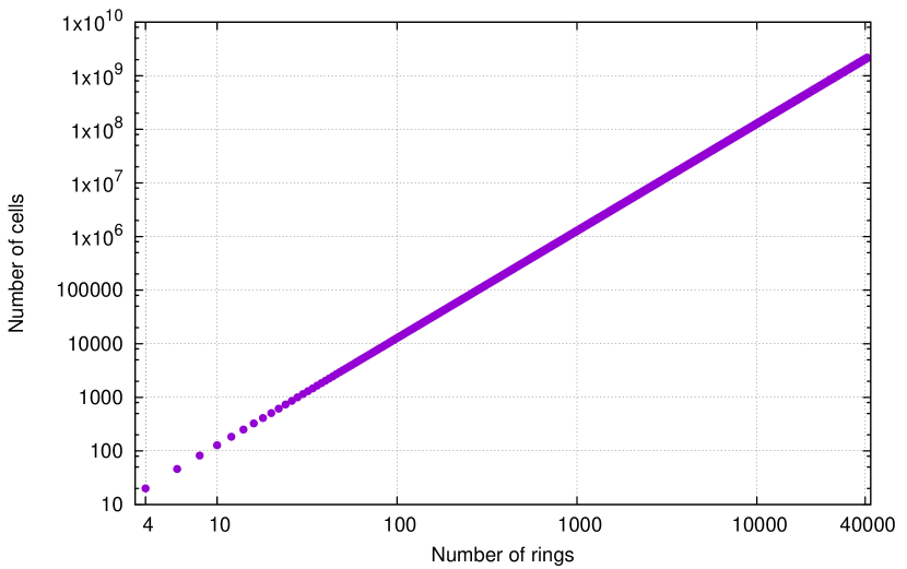
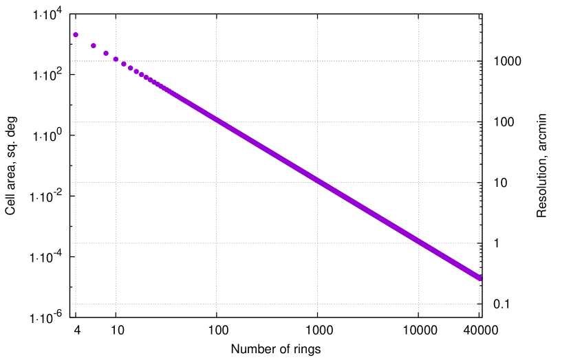
The number of the cells in the grid depending on is shown in Fig. 3. For 32-bit integer, maximum available is 41068. Therefore, the SREAG method provides detailed choice of the grid resolutions to satisfy a wide range of user requirements. For grid resolution varies from 45∘ to 16′′ (Fig 4). Analysis of the literature showed that the resolution used in practice lies in the range 7.3∘ to 26′′, which is fully covered by the SREAG resolution range. The latter can be extended using 64-bit integer.
If one starts with the desired , one can easily calculate the corresponding number of rings by with further rounding the result to the nearest even integer.
Another simple but accurate expression allows to approximate the grid resolution (in arcmin) as and thus obtain the required number of rings to provide the desired resolution. Again, must be even integer in the range [4:41068] for 32-bit compiler.
3. CONCLUSION
The new method SREAG is developed for subdividing a spherical surface into equal-area cells. The main features of the proposed approach are:
-
•
it provides an isolatitudinal rectangular grid cells with the latitude- and longitude-oriented boundaries with near-square cells in the equatorial rings;
-
•
it provides a strictly uniform cell area;
-
•
it provides a near-uniform ring width;
-
•
it provides a wide range of grid resolution with a possibility of detailed choice of desirable cell area;
-
•
the binned data is easy to visualize and interpret in terms of the longitude-latitude (right ascension-declinations) rectangular coordinate system, natural for astronomy and geodesy;
-
•
it is simple in realization and use.
Proposed approach to pixelization of a celestial or terrestrial spherical surface allows to construct a wide range of grids for analysis of both large-scale and tiny-scale structure of data given on a sphere. The number of cells is theoretically unlimited and is constrained in practice only by the precision of machine calculations.
The SREAG method can be hopefully useful for various practical applications in different research fields in astronomy, geodesy, geophysics, geoinformatics, and numerical simulation. In particular, it can be used in further analyses of the celestial reference frame, for selection of uniformly distributed reference sources in the next ICRF realizations, and for evaluation of the systematic errors of the source position catalogs.
4. SUPPORTING SOFTWARE
Several Fortran routines to perform basic operations with SREAG are provided at
http://www.gaoran.ru/english/as/ac_vlbi/#SREAG . They include:
| GRIDPAR.FOR | Compute parameters of the grid for a given number of rings. |
| CELLPAR.FOR | Compute the cell parameters for a given cell number. |
| POS2CN2.FOR | Compute the cell number for a given point position. |
| CN2POS2.FOR | Compute the cell center coordinates for a given cell number. |
| NR2NC.FOR | Compute the number of cells for a given number of rings. |
| NC2NR.FOR | Compute the nearest number of rings for a given number of cells. |
5. REFERENCES
Malkin, Z. (2019) A new equal-area isolatitudinal grid on a spherical surface, AJ, Vol. 158, id. 158, doi: 10.3847/1538-3881/ab3a44.