OpenHPS: An Open Source Hybrid Positioning System
Abstract.
Positioning systems and frameworks use various techniques to determine the position of an object. Some of the existing solutions combine different sensory data at the time of positioning in order to compute more accurate positions by reducing the error introduced by the used individual positioning techniques. We present OpenHPS, a generic hybrid positioning system implemented in TypeScript, that can not only reduce the error during tracking by fusing different sensory data based on different algorithms, but also also make use of combined tracking techniques when calibrating or training the system. In addition to a detailed discussion of the architecture, features and implementation of the extensible open source OpenHPS framework, we illustrate the use of our solution in a demonstrator application fusing different positioning techniques. While OpenHPS offers a number of positioning techniques, future extensions might integrate new positioning methods or algorithms and support additional levels of abstraction including symbolic locations.
1. Introduction
Determining the location of a person or asset is an important aspect of various human-computer interaction (HCI) solutions. Position tracking can be used to create autonomous vehicles, navigation systems and in context brokers such as CoBrA (chen2003ontology) to create implicit interactions based on the location and possibly other contextual information (schmidt1999there). While we mainly rely on the Global Positioning System (GPS) to determine our location outdoors, many other positioning techniques exist that work both, indoors as well outdoors and sometimes even have been designed for completely different use cases as described later in Section 2.1. Each positioning technique has its advantages and disadvantages depending on the environment where it is being used. Hybrid positioning systems use the combination of different techniques and sensors to determine a more accurate position through sensor fusion (chen2015fusion).
One of the disadvantages with most commonly used indoor positioning methods such as Bluetooth Beacons or Wi-Fi access point positioning is the requirement of some form of calibration or training. With our proposed hybrid system called OpenHPS111https://www.openhps.org, the goal is to achieve hybrid positioning during both, the navigation or tracking (online stage) and between tracking, training and calibration of the used positioning techniques (offline stage). Unlike many of the existing frameworks, the goal of OpenHPS is to offer a layered abstraction supporting a wide range of positioning techniques and fusion algorithms.
Using our knowledge on various positioning techniques and algorithms which are discussed in Section 2.1 and Section 2.2, we identified and analysed the actors of our system as highlighted in Section 4.1.1. This analysis revealed that actors play a different role depending on the positioning method being used. In order to allow the system to combine different existing positioning methods, we opted for a processing stream network where each node in a graph topology contributes to the sampled data.
Our design goal with the chosen processing network is to handle positioning data in real time, giving developers complete control over the data flow. The proposed OpenHPS framework is presented in Section 4 together with an illustrative demonstrator use case before discussing some future work in Section LABEL:sec:conclusion.
2. Background
The first step in conceptualising our hybrid positioning framework was to investigate existing positioning methods in order to find their similarities as well as differences. OpenHPS has to be able to support a wide range of different positioning methods and implementation goals. When analysing existing approaches, we made a distinction between positioning methods and algorithms, similar to Wilson et al. (sakpere2017state). Positioning methods represent the techniques and technologies that are available to determine a location while positioning algorithms include the algorithms that can be used to combine these methods.
2.1. Positioning Methods
In this section we list some of the more prominent positioning methods ranging from signal-based to visual solutions. Note that the selected positioning methods represent a limited set of the techniques and functional requirements we aim to support.
2.1.1. Global Position System (GPS)
Starting with the most well-known technology, the Global Positioning System (GPS) is used for outdoor positioning (bulusu2000gps). It makes use of satellites in an orbit around the Earth to triangulate a location consisting of a longitude, latitude and elevation. There also exist variations on the original global position system, including Differential GPS (DGPS) (rezaei2007kalman) or the Assisted GPS (a-GPS) (djuknic2001geolocation) that fuses GPS with dead reckoning described later in Section 2.1.5.
2.1.2. RF-based Positioning
RF-based positioning is a commonly used technique for indoor environments. Examples of technologies used for RF-based positioning include Wi-Fi, Bluetooth Beacons, RFID and LTE cell towers. These RF signals offer a landmark that can be used as a reference when determining the position based on fingerprinting or other mathematical calculations.
2.1.3. Simultaneous Localisation and Mapping (SLAM)
Simultaneous Localisation and Mapping, or SLAM for short, is a positioning method that makes use of 2D sensors to map its surroundings. One of the more common examples includes the use of LIDAR (Light Detection and Ranging) (mendes2016icp), capturing distance readings around a sensor. These readings can then be used to generate a 2D map of the environment.
2.1.4. Visual Positioning Techniques
Existing visual positioning techniques use image sensors to determine the position of the object the sensor is attached to (e.g. Visual SLAM (openvslam2019)) or the position of objects in its field of view. In previously mentioned positioning methods, the tracked object obtains the sensor data. With Multi-Target Multi-Camera Tracking (MTMCT) (krumm2000multi) the tracked object is moving within the field of view of one or more image sensors.
2.1.5. Dead Reckoning
Dead reckoning calculates the current position based on the previous known position and the velocity or acceleration that is applied to that position (holzke2019improving; beauregard2006pedestrian). While the accuracy of dead reckoning is not ideal, it can be used to improved other positioning techniques such as GPS.
2.2. Positioning Algorithms
In order to calculate a position or to combine multiple positioning methods, different algorithms are used. The list of algorithms presented in this section offers a baseline for the types of positioning algorithms to be supported, but our OpenHPS framework is not limited to the presented set of algorithms.
2.2.1. Triangulation and Multilateration
Mathematical operations such as triangulation and multilateration can be used for several positioning methods and technologies discussed in Section 2.1. For techniques that provide a landmark such as RF-based positioning, the received signal strength (RSS) might provide a rough estimate of the distance. Other examples include mathematical positioning using a time difference with respect to the time of arrival (ToA) or the angle of arrival (AoA).
2.2.2. Fingerprinting
While with multilateration we only need information about the position of the used landmarks, fingerprinting requires a calibration for all possible positions in the tracking area (xiao2011integrated). A fingerprint of the sensor data at a given provided position is created during the offline stage. Later, these stored fingerprints are used during the online stage to reverse the sensor data into a position.
2.2.3. Noise Filtering
Sensor data should be filtered, which can be done through different noise filters. Similar to dead reckoning, a noise filter often requires knowledge of previous sensor readings and positions to predict the next result.
Noise filtering is one of the main requirements of our hybrid positioning system. The reason why we want to combine multiple technologies or algorithms is to reduce errors and noise filtering is the key component in realising this error reduction of positioning data. Note that individual positioning methods such as object recognition or dead reckoning may want to perform different types of noise filtering algorithms tailored to their data.
2.2.4. Machine Learning
This type of algorithms includes a number of machine learning algorithms that can be of aid during calibration as well as positioning. These algorithms require training during the offline stage with the results being deployed during the online stage. This issue will be further discussed when discussing the requirements in Section 4.1, where we allow data to be used in the online and offline stages of the OpenHPS framework.
2.2.5. Computer Vision
With the visual positioning methods discussed in Section 2.1.4, the tracked actor is not always uniquely identified. Such visual positioning methods have to be able to detect and track objects between multiple frames, camera angles or positions. The algorithms used to track and detect persons or objects from a video stream are beyond the scope of our framework, but OpenHPS should be able to provide a generic interface supporting these types of algorithms.
2.3. Hybrid Positioning
Apart from supporting different positioning methods and algorithms, OpenHPS should be able to combine these methods. This requires a choice of algorithms to specify how the result of each method can be used in the combined output.
Sensor fusion can occur at a low or high level (elmenreich2002introduction). Raw sensor data such as IMU sensors or the relative signal strength from a transmitter can be fused in noise filtering algorithms. On a high level, calculated or provided positions (i.e. by third-party positioning systems) with a certain predicted accuracy can be combined using linear regression, heuristic weighted averages or any decision fusion algorithm.
3. Related Work
Location-based Services (LBS) represent a generalised category of systems that provide the current location of a person or other objects (kupper2005location). A distinction between a push- and pull-based LBS is made (steiniger2006foundations). A pull LBS provides a location when it is requested to do so, while a push LBS delivers information when a new location is determined by a provider.
The idea of combining multiple positioning methods in an LBS is not new. In this section we present some related work, ranging from existing hybrid positioning systems, frameworks, their used terminology and standards throughout location-based services.
3.1. Location APIs and Specifications
On the Web, the Geolocation API (popescu2010geolocation) offers a high-level interface for single or repeated position updates. The API provides an abstraction of the underlying technologies and algorithms used to determine the position. However, developers can request a high accuracy result or maximum cache age if hardware permits this. Resulting positions are geographical coordinates complying with the WGS84 standard (decker1986world).
JSR-179 and the improved JSR-293 (barbeau2008location) specifications are Java 2 Micro Edition (J2ME) modules that provide developers an API to obtain the location and orientation of a mobile device. Included in the API is a storage interface for landmarks (see Section 2.1.2). The specification represents locations as timestamped coordinates with an orientation, accuracy, speed and information about the used positioning method (di2005indoor). When requesting a location, criteria such as the desired accuracy, power consumption and response timeout can be provided.
WebXR (jones2019webxr; maclntyre2018thoughts) is a Web API that provides an interface for the tracking and use of VR or AR headsets. The API uses the pose terminology to indicate the position and orientation of the person wearing an XR headset in 3D space. While WebXR should not be considered as a location API, its specification uses terminology that is common in our framework. As an API that provides a tracking position, it adds a goal for our framework to support these third-party APIs.
3.2. Hybrid Positioning Systems
Various research concerning the fusion of sensor data to predict a more accurate position exists. SignalSLAM (mirowski2013signalslam) represents an example of a hybrid system that uses signals of various positioning methods such as GPS, Wi-Fi and Bluetooth to map the surroundings. Chen et al. (chen2015fusion) have shown how a smartphone can combine sensor data of Wi-Fi access point positioning and Pedestrian Dead Reckoning (PDR). This combination of dead reckoning with another positioning method is a common combination used by many hybrid systems. LearnLoc (pasricha2015learnloc) is a smartphone-centred positioning framework that uses fingerprinting algorithms (k-nearest neighbours algorithm) in combination with various sensor data available on a smartphone to provide power-efficient indoor positioning. The consideration of power efficiency is a common requirement in mobile positioning systems. Other than achieving the most accurate position, these location-based services use sensor fusion to prevent the continuous use of precise sensors such as cameras or GPS.
IndoorAtlas provides a Platform-as-a-Service (PaaS) with a well-established Software Development Kit (SDK) for combining Wi-Fi, GPS, Bluetooth beacons, dead reckoning and even geomagnetic positioning (haverinen2014utilizing). While the latter method has been found to be less ideal in steel reinforced buildings (pasricha2015learnloc), it still offers a useful addition for creating a hybrid positioning system where geomagnetic positioning might be combined with other positioning methods.
In the research by Bekkelien and Deriaz (bekkelien2012hybrid) a framework called Global Positioning Module (GPM) had been presented for in- and outdoor positioning. GPM provides a uniform interface to different position providers. These providers are fused in a kernel that selects the position based on provided criteria (e.g. precision, accuracy or detection probability). Their approach offers a clear methodology on how this criteria can contribute to the selection or fusion of different technologies. However, the position providers and kernels are implemented on a high level of abstraction providing no room for developers to choose different algorithms or fusion techniques.
Ficco and Russo (ficco2009hybrid) presented a technology-independent hybrid positioning middleware called HyLocSys. Position estimators, representing different technologies, provide positions when a user performs a pull of their current position. Sensor fusion combines these estimated positions into a final response. With the middleware being an extension of the JSR-179 specification presented earlier, these pull requests accept criteria such as the preferred response time and expected accuracy. Other than many frameworks that only provide geographical positions, HyLocSys provides geometric, symbolic as well as hybrid location models. Symbolic locations represent abstract places such as buildings, floors and rooms that are relatively positioned to each other. A hybrid location can convert this symbolic location to a geometric position. Note that the paper does not discuss positioning technologies such as dead reckoning or SLAM that require periodic updates in order to keep an up-to-date position.
Scholl et al. (scholl2012fast) propose a system that uses a LIDAR scanner to determine the fingerprinting position. This is somewhat similar to our goal of using different positioning methods to support the offline stage.
The Robot Operating System (ROS) (quigley2009ros) is a structured communication layer that can be used to create autonomous robots. It focuses on the integration of various robotics aspects such as positioning, computing and hardware interfacing. ROS provides the concept of peer-connected nodes that perform computational tasks. These nodes represent interchangeable software modules that help to build a pipeline from sensory data to an output action. For positions and orientations, ROS uses the pose concept which contains both the position and orientation of a user.
Our framework should adhere to specifications such as WGS84 when working with geographical positions. However, unlike many of the related work discussed in this section, we also want to support non-geometric positions. The hybrid location model presented by Ficco and Russo (ficco2009hybrid) offers a good type of location, but is still heavily focused on geometric positions.
Positioning methods and algorithms are often represented under the term providers that are optionally combined via high-level decision fusion. In our framework, we want to separate providers into generic algorithms and positioning methods that can easily be switched. This not only allows for more extensibility, but also some low-level sensor fusion.
The Geolocation API, JSR-179 and HyLocSys allow for the specification of accuracy or other criteria when requesting a position. However, unlike high-level APIs that hide the underlying technologies, OpenHPS is aimed towards developers with an understanding of the available hardware and positioning techniques that influence the criteria.
The landmark storage of JSR-179 is a very useful addition to a positioning system, as it is a common requirement for many positioning techniques. The persistence of landmarks between the online and offline stage is an important requirement that is extended to fingerprinting information and cached position storage in OpenHPS. This persistence should allow us to interface with existing systems such as the Geolocation API that support both push-based position updates as well as retrieving the current (cached) position.
4. OpenHPS Framework
In this section, we present and discuss the system design of our proposed OpenHPS hybrid positioning framework. After listing some general requirements in Section 4.1, we outline the overall architecture in Section 4.2. Next, we provide some general information on our chosen implementation and demonstrate the use of OpenHPS in Section LABEL:subsec:implementation and Section LABEL:subsec:demonstrator.
4.1. Requirements
Based on existing positioning methods and algorithms discussed in Section 2.1 and Section 2.2, the following framework requirements have been derived. We start by specifying the actors of our system and motivate the use of a processing network where each node of the graph topology might represent one of these actors.
4.1.1. System Actors
After investigating different existing positioning techniques, we defined four actors in OpenHPS:
-
•
Tracked actor: This is an actor that can be tracked during the online positioning stage. A tracked actor can be an end user or an asset that might optionally contain sensors to further support the tracking. Our main goal is to determine the most accurate position of this type of actor.
-
•
Tracking actor: This type of actor is responsible for tracking a tracked actor. Note that for some positioning methods, the same actor might act as a tracking actor as well as a tracked actor. However, for positioning methods such as the visual object tracking introduced in Section 2.1.4, the tracking actor is represented by the camera while a tracked actor is the object that is being detected.
-
•
Calibration actor: Some positioning methods require a calibration before the positioning method can be used. Unlike the tracked actor, the purpose of a calibration actor is to train and calibrate how the tracking actor will be used in the online stage of the system.
-
•
Computing actor: The computing actor is responsible for providing the final position output by our system. This actor combines the data generated by one or more tracking actors about a tracked actor and processes the data by, for example, using one of the positioning algorithms described in Section 2.2.
These four actors represent the four main components within OpenHPS. By distinguishing between the tracked and tracking actor, the system is able to support the tracking of persons or objects that do not actively participate in the positioning process.
4.1.2. Functional Requirements
In the following, we list the minimal functional requirements for our OpenHPS framework.
-
•
Online stage positioning: In order to perform hybrid positioning or sensor fusion, multiple (processed) sources need to be combined by using different algorithms.
-
•
Offline stage positioning: Processed results can be used to calibrate positioning methods of another (online) stage.
-
•
Third-party frameworks: Our framework needs to support third-party high-level positioning systems. These external systems might provide their own calculated position of a tracked actor that needs to be fused with the position determined by our framework. In addition, the identification of this tracked actor might differ between frameworks.
-
•
Environment mapping: With the requirement to support positioning methods such as SLAM and VSLAM, the system does not only offer the possibility to output an absolute position, but might also create an environment map. Our solution should be capable of handling, storing and using this map to its advantage.
-
•
Decentralisation: Our positioning framework should be able to combine the four different actors introduced in the previous section based on remote hardware. This requires the framework to work decentralised without requiring any centralised sensor fusion, which can be achieved by allowing multiple computing actors to work independently. However, developers should still be given the option to centralise certain parts of the system if needed.
-
•
Monotonicity: Partial information from a source should result in a partial output. In the context of a positioning system, this means that a computing actor does not need the sensor data of all positioning methods to determine a position. This requirement also helps in the decentralisation and parallelisation of the framework.
4.1.3. Non-functional Requirements
The following non-functional requirements contributed to the final decision about the software language used for OpenHPS.
-
•
Availability: Our solution has to be available on various platforms ranging from servers to embedded systems; also supporting the decentralisation functional requirement.
-
•
Performance and latency: Throughput is an important criteria when processing streaming data. Input data such as video and audio streams needs to be processed in real time. The latency also indicates how long it takes for data to be used in computations. As our goal is to achieve an accurate current position, outdated sensor data is not relevant.
-
•
Modularity: The framework should be modular with both, a low-level API and modules that can be added and removed based on the available sensors and concrete use cases. Developers should remain in control of the types of algorithms and the flow of data from producer to consumer.
4.2. Framework Architecture
In order to support the presented functional and non-functional requirements, we decided to build on a stream-based positioning system that takes various types of input data and processes this data to get the desired output. Data that is transmitted between nodes is encapsulated in so-called data frames that can contain sensory data as well as one or more data objects the sensor data applies to, and are described in detail in Section LABEL:subsubsec:data-frame.
For the design of our process network, a number of existing stream- and layer-based frameworks such as Akka Streams (davis2019akka) or TensorFlow (abadi2016tensorflow) have been investigated. These frameworks solve similar issues and are further detailed in Section 4.2.1. Due to the fact that each node needs to be configured individually, the decision was made to investigate flow-based frameworks where each component of the stream network is added individually.
Unlike low-level data stream frameworks, OpenHPS focuses on data that is helpful for positioning. We offer a higher-level API for creating the network and data that is handled by the sytem. Concepts such as edges or ports that are often found in stream-based programming languages are abstracted and not directly accessible by developers. However, unlike other hybrid frameworks (haverinen2014utilizing; bekkelien2012hybrid), the stream processing is extensible enough to give developers the opportunity to modify the positioning methods along with the used algorithms.
We start by discussing our process network design that uses a graph topology similar to other stream frameworks. Next, we present the data frames, objects and positional data that are being handled by the network.
4.2.1. Process Network Design
The OpenHPS framework uses a process network to handle data. The data is processed and dynamically manipulated by multiple connected nodes in a predefined graph topology. In the following, we list our three main design goals for this network:
-
(1)
Consistent data types: Data that is being processed in the network should have a reliable type and content. We process
DataObject}s encapsulated in \mintinlinetypescript
DataFrames, which provides a defined scope how generic parts of our network should handle information.
Processing goal: Processing has the goal of providing an absolute position for our tracked actors. With this goal we have a clear understanding how every computing actor contributes to the output.
Producer priority: The producer or tracking actor has the highest priority. Slow consumers or computing actors must not result in outdated sensor information. Rather, developers should be given the opportunity to control what happens with the overflow of information that cannot be processed timely.
Starting from the goal of producing up-to-date positioning information, we opted for a push-pull-based stream. Data can be dropped if its not relevant for determining a more up-to-date position. The monotonicity of our framework ensures that positions can be determined based on partial data. Each node can be designed to accept both push and pull requests. Similar to reactive streams (geilen2004reactive), push and pull actions are promise-based and can be executed asynchronously. If a node that receives a pull request cannot respond with a data frame itself, it will forward the pull request to its incoming node(s). Different to a traditional pull that returns a response, we use the push terminology to indicate a response for a given pull. This behaviour and terminology is similar to Akka Streams (davis2019akka), but unlike reactive streams where data can only be provided when there is a demand, there is no back pressure built into the stream itself. Using the push terminology for a pull response removes the ambiguity of a response arriving after an already existing push in the pipeline. It also enforces the design goal of producers having the highest priority, even if a producer only generates information when requested. A regular node has a unique identifier and push/pull functionality for data frames. Each node can have inlets or outlets. Our system consist of the following three subtypes of the regular node:
-
•
Source node: A source node provides a specific data type. This can either be a push or pull node that pushes data frames when they are available (e.g. a camera recording at a fixed frame rate) or creates a new data frame when the downstream node asks for it via a pull request (e.g. triggering a Bluetooth scan). The source node merges data objects in the data frame with those that were previously stored via data services. This merging behaviour prevents the need for feedback loops to gain knowledge on previously calculated positioning data.
-
•
Processing node: A processing node is a higher-level interface for a regular node. It provides an abstraction on the push and pull functionality to simplify the creation of a processing function of either data frames or individual data objects.
-
•
Sink node: An output node or sink node accepts a specific data type as output frame. Unlike processing nodes, this type of node will not push data to other nodes. Upon receiving a data frame, the data objects will be stored using a compatible data service. Once saved, an event is sent upstream to indicate that the processing of this frame and its contained objects is completed.
Extensions of these nodes, allowing for specific data flow shapes and common position processing nodes, are provided in our core component. Figure 1 shows an example of a positioning model that has a source node, a sink node and four processing nodes connected in a graph structure. This positioning model describes a configured computational model aimed for processing sensor and positioning data (lee1995dataflow). Similar to existing streaming or pipelining frameworks, the graph can contain data flow shapes that manipulate the flow of data frames. Examples of such shapes include, but are not limited to balance nodes, data frame chunking, debouncing and merging of data objects and their processed positions.
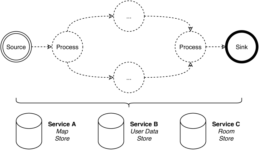
Image illustrates the positioning model used in OpenHPS. A source and sink is shown with processing nodes inbetween. Underneath the nodes three services (represented as a data store) are shown for map storage, user data storage and room storage
All nodes in a positioning model have access to a set of services that allow the storage of objects. In the given example, three services are added for the storage of map, user data and room information. In our implementation, sink nodes always store data objects contained in received data frames. However, every node has the ability to fetch or insert new data into available services. This persistence allows for the storage of landmark objects, similar to the JSR-179 specification (di2005indoor). At the same time, these services can be used as an interface to fetch the latest position without requiring a specific implementation in the sink. The positioning model can be created by using a builder pattern as illustrated in Listing LABEL:lst:openhps-model. This builder creates the immutable properties of the model, including data services and the flow of data from source to sink. Models can have multiple flow shapes, each with one or more sources, processing nodes and sinks.