Semantic Identifiers and DNS Names for IoT
Abstract
In this paper, we propose a scheme for representing semantic metadata of IoT devices in compact identifiers and DNS names to enable simple discovery and search with standard DNS servers. Our scheme defines a binary identifier as a sequence of bits: a Context to use and several bits of fields corresponding to semantic properties specific to the Context. The bit string is then encoded as base32 characters and registered in DNS. Furthermore, we use the compact semantic DNS names to offer support for search and discovery. We propose to take advantage of the DNS system as the basic functionality for querying and discovery of semantic properties related to IoT devices.
We have defined three specific Contexts for hierarchical semantic properties as well as logical and geographical locations. For this last part, we have developed two prototypes for managing geo-identifiers in LoRa networks, one based on Node and the Redis in-memory database, the other one based on the CoreDNS server.
Index Terms:
Internet of Things, Semantic identifiers and names, DNS, W3C Thing Description, LoRa, GeohashesI Introduction
Many IoT applications require the knowledge about the various properties of IoT devices that provide some data about the physical world and can act upon the environment. The properties may for instance include the information on:
-
•
type and unit of data, (e.g., temperature in °C),
-
•
resolution, frequency of data (e.g., pixels every hour),
-
•
possible actions performed by the device (e.g., switch on),
-
•
raised alarms (e.g., overheating),
-
•
geographic location of the device (e.g., WGS84/GPS coordinates),
-
•
logical location of the device (e.g., Room 235 on Floor 14).
Several initiatives aimed at expressing and structuring this kind of IoT and M2M metadata: Sensor Markup Language (SenML) [1], IPSO Alliance Framework [2], and oneM2M Base ontology [3]. The World Wide Web Consortium (W3C) schemes for the semantic Web such as RDF,111http://www.w3.org/RDF OWL,222http://www.w3.org/TR/owl-ref SPARQL333http://www.w3.org/TR/sparql11-query/ also allow understanding and discovery of IoT data. For expressing specific IoT semantics, W3C proposed a Semantic Sensor Network (SSN) ontology444https://www.w3.org/2005/Incubator/ssn/ssnx/ssn that allows the description of sensors and their characteristics addressing the issue of interoperability of metadata annotations.
The Web of Things initiative of W3C555https://www.w3.org/WoT aims at unifying IoT with digital twins for sensors, actuators, and information services exposed to applications as local objects with properties, actions, and events. W3C Thing Description (TD)666https://www.w3.org/TR/wot-thing-description expressed in JSON-LD777https://www.w3.org/TR/json-ld covers the behavior, interaction affordances, data schema, security configuration, and protocol bindings.
Thing Description allows for attaching rich semantic metadata to IoT devices, however, this format is oriented towards processing by non-constrained applications running for example in the Cloud or in the Edge to become the base for sophisticated discovery and search services offered on Web servers for IoT users and applications. However, we can notice that discovery and search based on semantic metadata also happens in constrained IoT environments—an IoT device needs to discover other devices and choose the right one for further communication or collaboration. In this case, semantic metadata of IoT devices need to be encoded in a highly compact way to reduce the overhead in usually bandwidth limited networks.
In this paper, we propose a scheme for representing semantic metadata of IoT devices in compact identifiers or names to enable simple discovery and search with standard DNS servers. The idea of the scheme is inspired by the Static Context Header Compression (SCHC)888https://tools.ietf.org/html/rfc8724 approach to IP header compression. In SCHC, two devices that exchange IP packets compress headers based on pre-established contexts. Instead of a full header, a device inserts the information about the context to use and some short information required to reconstruct the header. In this way, a 40 byte IPv6 header can be compressed down to just a few bytes. Our scheme defines a binary identifier as a sequence of bits composed of a Context to use and several fields corresponding to semantic properties specific to the Context. The bit string is then encoded as base32 characters and registered in DNS. Thus, the DNS name encodes in a compact form the semantic metadata of an IoT device.
We define several Contexts of identifiers expressing different semantic metadata to fit the most popular device characteristics (other can also be defined):
-
1.
hierarchical semantic properties,
-
2.
logical location of the device,
-
3.
geographic location of the device.
The first one corresponds to the structured representation of the attributes of Thing Description and two others cover the geographical information about an IoT device. We instantiate the scheme for encoding geographic location in case of LoRa networks and show how to construct a 64 bit geo-identifier of LoRa devices.
Furthermore, we use the compact semantic DNS names to offer support for search and discovery. In constrained environments, providing full-fledged database search functionality may be difficult. Instead, we propose to take advantage of the DNS system as the basic functionality for querying and discovering the semantic properties related to IoT devices. Our encoding scheme of semantic metadata structures the DNS names similarly to IP prefixes: a longer prefix represents more specific information and shortening a prefix corresponds to more general information, thus allowing for some range or extended topic queries. For instance, if the name represents a geographical location, a longer name represents a smaller area and a shorter name corresponds to a larger zone that encompasses the smaller area designated by the longer name. Finally, we describe two prototypes supporting DNS queries on geo-identifiers.
Querying DNS based on semantic names can bring interesting features to many IoT applications: finding devices corresponding to a given property, placement on a map of all sensors belonging to a given application, sending commands to the devices in a chosen region, or gathering data from chosen devices based on their geographical location.
The paper makes the following contributions:
-
1.
we define a scheme based on Contexts for compact encoding of different types of metadata in DNS names,
-
2.
we take advantage of geohashes to instantiate the scheme for encoding geographic location,
-
3.
we propose a means for simple and minimal discovery of IoT devices and searching for their characteristics based on standard DNS functions,
-
4.
we explore an idea of using DNS to store and publish IoT data,
-
5.
we validate the proposed schemes with preliminary prototypes supporting DNS queries on geo-identifiers.
II Related Work
We briefly review previous work related to expressing semantic properties of IoT devices and compact encoding of geographical location.
II-A Semantic Properties of IoT Devices
As mentioned in the introduction, several initiatives considered the problem of expressing metadata of IoT devices and M2M communications: Sensor Markup Language (SenML) [1], IPSO Alliance Framework [2], and oneM2M Base ontology [3]. Kovacs et al. proposed a system architecture for achieving worldwide semantic interoperability with oneM2M [4]. The Semantic Sensor Network (SSN) ontology allows the description of sensors and their characteristics [5].
An important initiative of W3C aimed at creating the semantic Web of Things [6] to enable unambiguous exchange of IoT data with shared meaning. Novo and Di Francesco [7] discussed solutions that extend the Web of Things architecture to achieve a higher level of semantic interoperability for the Internet of Things. Nevertheless, many proposed approaches do not address the constraints of IoT devices that do not match the size and the form of semantic descriptions usually developed in the traditional W3C setting. For instance, Novo and Di Francesco [7] reported performance results coming from a testbed composed of two computers connected to an 802.11 network.
II-B WGS84 aka GPS
WGS84 is a common format for encoding geographical coordinates used in GPS, composed of two numbers in degrees of the form ddd.ddddddd, where d stands for a degree digit. Degrees are expressed as numbers between and for longitude, and a number between and for latitude (locations to the west and to the south are negative), e.g., corresponds to the location of the Cape Canaveral Space Center.
Expressing a given geographical location is always done with a given precision, and when decoding a position, all methods return the center of the square representing all possible positions. For example, if we decode , we know the position is in the square between and , and we will return to minimize the error.
Table I represents the longitudinal resolution at the equator and at a latitude of with an increasing number of decimal figures and the corresponding number of bits to represent them. The idea is to relate the size of a region to the number of bits used for representing a given geographical coordinate and thus relate the size of a region to the size of an identifier. We can observe that 8 decimal figures encoded on 26 bits are sufficient to represent the location at the precision of around 1 m.
| # of figures | # of bits | Equator | |||
|---|---|---|---|---|---|
| 3 | 9 | 111. | 3200 km | 78. | 710 km |
| 4 | 12 | 11. | 1320 km | 7. | 871 km |
| 5 | 16 | 1. | 1132 km | 787. | 100 m |
| 6 | 19 | 111. | 3200 m | 78. | 710 m |
| 7 | 22 | 11. | 1320 m | 7. | 871 m |
| 8 | 26 | 1. | 1132 m | 787. | 100 mm |
II-C Geoprefixes, Geohashes, Plus Codes
In previous work, we defined the notion of a geoprefix for IPv6 networks [10]: the location of each device is encoded in its IPv6 multicast address and an application can send a packet to all devices corresponding to a given prefix representing a geographic area (a geocast).
Niemeyer [11] proposed geohash, an encoding of WGS84 coordinates based on Morton codes [12] that computes a 1-dimensional value from the 2-dimensional GPS coordinates by interleaving the binary representations of the coordinates and further represented as ASCII characters.
In this method, to encode a given location, we proceed by a dichotomy. Starting with the full interval ( for longitude, for latitude), we split the interval in two ( and for latitude), then, if the location is in the higher half, we add bit 1 to the encoding of the coordinate, or else, we add bit 0, and we repeat the operation with the new interval, building the encoding bit by bit, until we reach the desired precision. When decoding, once the last bit is reached, the decoded location is at the center of the remaining interval (for latitude, if we have only one bit with value 1, we would decode that the latitude is ). With this method, each additional bit halves the size of the interval.
Once both latitude and longitude are represented this way, their binary codes are intermingled to produce a unique value: odd bits represent latitude and even bits represent longitude as presented in Table II. For example, the resulting encoding of latitude 1011 1100 1001 and longitude 0111 1100 0000 is 0110 1111 1111 0000 1000 0010.
| Long. | 0.1.1.1.1.1.0.0.0.0.0.0.0 |
|---|---|
| Lat. | .1.0.1.1.1.1.0.0.1.0.0.1. |
| Result | 0110111111110000010000010 |
| length | lat bits | lng bits | lat error | lng error | error |
|---|---|---|---|---|---|
| 1 | 2 | 3 | 23° | 23° | 2500 km |
| 2 | 5 | 5 | 2.8° | 5.6° | 630 km |
| 3 | 7 | 8 | 0.70° | 0.70° | 78 km |
| 4 | 10 | 10 | 0.087° | 0.18° | 20 km |
| 5 | 12 | 13 | 0.022° | 0.022° | 2.4 km |
| 6 | 15 | 15 | 0.0027° | 0.0055° | 610 m |
| 7 | 17 | 18 | 0.00068° | 0.00068° | 76 m |
| 8 | 20 | 20 | 0.000085° | 0.00017° | 19 m |
| 9 | 22 | 23 | |||
| 10 | 25 | 25 | 59 cm | ||
| 11 | 27 | 28 | |||
| 12 | 30 | 30 | 1.84 cm |
Geohash-36,999http://en.wikipedia.org/wiki/Geohash-36 originally developed for compression of world coordinate data, divides the area into 36 squares and generates a full character describing which sub-square contains the position.
Google Maps uses Plus Codes [13, 14] made up of a sequence of digits chosen from a set of . The digits in the code alternate between latitude and longitude. The first four digits describe a one degree latitude by one degree longitude area, aligned on degrees. A Plus Code is 10 characters long with a plus sign before the last two:
-
1.
The first four characters are the area code describing a region of roughly 100 100 kilometers.
-
2.
The last six characters are the local code, describing the neighborhood and the building, an area of roughly 14 14 meters.
As an example, let us consider the Parliament Buildings in Nairobi, Kenya located at the 6GCRPR6C+24 plus code: 6GCR is the area from 2S 36E to 1S 37E. PR6C+24 is a 14-meter wide by 14-meter high area within 6GCR. The + character is used after eight digits, to break the code up into two parts and to distinguish codes from postal codes.
III Compact Encoding of IoT Metadata
The main objective of this paper is to design a scheme for encoding semantic properties in DNS names so that IoT devices could discover relevant nodes using with DNS name resolution. Figure 1 gives an example of how it can be done in the context of LoRa devices. Note that DNSSEC guarantees the information integrity.
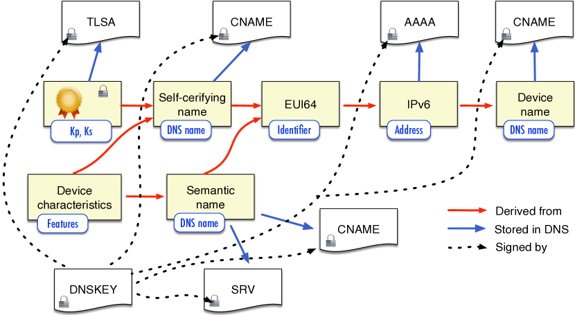
We propose to assign self-certifying names to IoT devices: the name derives from a public key to enable secure establishing of the identity of a device without relying on an external PKI infrastructure. The self-certifying name is constructed as a hash of public key similarly to Bitcoin addresses:
then is encoded with base32 (20 characters) giving the DNS name . base32 encoding represents a binary string with 0-9 digits and some lower case letters (excluding characters hard to distinguish like i, l, o). We cannot use base58check like in Bitcoin because of capital/low case letters in base58check (DNS names do not distinguish between capital/low case letters). The nice feature of this scheme is that devices can check whether a public key from the TLSA DNS record corresponds to the name and if authentication is enforced (signature with the private key ) to be sure a device communicates with the right peer.
Then, we can derive an 8 byte EUI64 identifier from with SHA-3(). EUI64 identifiers are required in some networks like LoRa—we can obtain the LoRa DevEUI identifier derived from and then use it to construct an IPv6 address. We will also show below that the DevEUI of a LoRa device can represent its geographical location.
In addition to the self-certifying name, we define other names (DNS aliases) that represent device properties encoded in a compact way. Moreover, we want the encoding scheme to take advantage of some discovery functionalities of DNS by requiring that a name is structured as an IP prefix—smaller prefix means a more general query.
III-A Encoding Hierarchical Semantic Properties
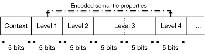
Figure 2 presents the structure of an identifier encoding a semantic tree of several levels presented below. A Context defines how to interpret the encoded semantic properties. The first type of Contexts we define is a hierarchical representation of properties in a form of a semantic tree with leaves corresponding to properties (see example in Figure 3). The identifier encoding the semantic properties is the binary code generated when traversing the tree. To be able to express the binary identifier of a level with one or more base32 letters, each field is 5 bits or a multiple of 5 bits (e.g., the Level 3 field composed of 10 bits). In this way, we avoid problems of dealing with padding if the size of the binary identifier is not a multiple of 5 bits. Note that the structure of a given identifier (the size of each field) is defined by a given Context.
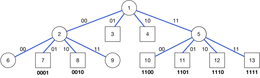
Figure 3 presents an example of a semantic quadtree of degree for simplicity. In fact, we use for 5 bits assigned to each level of the tree, which gives the possibility of representing attributes at Level 2 or more, e.g., at Level 3 with the field of 10 bits. We may have trees with different numbers of nodes at each level depending on the need of representing more or less properties (e.g., , if we assign 10 bits to a level), the only limitation being that the level degree should be a power of . Circles correspond to non-terminal nodes and squares to leaves.
The position in the tree determines the code of a property, for instance, the property at leaf has the code of 1101 corresponding to the traversal of the 11 branch and then, the 01 one. One identifier (so one DNS name) corresponds to one leaf in the tree.
The encoding scheme structures the DNS names similarly to IP prefixes: a longer prefix represents more specific information and shortening a prefix corresponds to more general information, thus allowing for some range or property queries, e.g., the shorter code of 11 represents all properties with 1100 1101 1110 1111 identifiers.
Below, we present an example of creating a semantic name for a temperature sensor with metadata expressed in the following W3C Thing Description:101010https://www.w3.org/TR/wot-thing-description
”@context”: [
    ”https://www.w3.org/2019/wot/td/v1”,
…],
”@type”: ”saref:TemperatureSensor”,
…
”properties”: {
    ”temperature”: {
        ”description”: ”Weather Station Temperature”,
        ”type”: ”number”,
        ”minimum”: -32.5,
        ”maximum”: 55.2,
        ”unit”: ”om:degree˙Celsius”,
        ”forms”: […]
    },
    …
},
…
where some attributes refer to external vocabularies such as SAREF (Smart Appliances REFerence Ontology)111111https://ontology.tno.nl/saref/ and OM (Ontology of Units of Measure)121212http://www.ontology-of-units-of-measure.org/page/om-2.
The encoded binary identifier is composed of the following fields (base32 encoding in parenthesis131313In all our encoding examples, we use the base32 version defined for geohashes that encode geographical coordinates instead of the version described by RFC 4648, https://tools.ietf.org/html/rfc4648.):
-
•
00001 — Context-1 (1)
-
•
01100 — properties (d)
-
•
00001 — temperature (1)
-
•
00101 — unit (5)
-
•
00010 — degree_Celsius (2)
We assume that Context-1 corresponds to the semantic tree generated according to the TD context with 5 bits per level, properties is the 12th attribute, temperature the 1st one, and the value of the unit degree_Celsius is the 2nd possible value. The binary identifier of 00001 01100 00001 00101 00010 results in the 1d152 DNS name.
III-B Encoding Logical Location
In many use cases, an IoT application may benefit from metadata about localization in a logical form. For instance, when defining group communication for the Constrained Application Protocol (CoAP), RFC 7390141414https://tools.ietf.org/html/rfc7390 considered a building control application that wants to send packets to a group of nodes represented by the following name:
all.bu036.floor1.west.bldg6.example.com.
Logically, the group corresponds to ”all nodes in office bu036, floor 1, west wing, building 6”. Such hierarchical groups of fully qualified domain naming (and scoping) provide a logical description of places that may complement other precise geographical information that we consider in the next section.
We can observe that there is an inclusion relationship between elements of the description: office bu036 is on the floor 1, at the west wing of building 6. A specific Context can represent the inclusion relationship in a semantic tree, so we can express a given logical location with a binary identifier and an encoded DNS name.
Let us assume that we have up to 32 buildings, 32 floors, and 1024 rooms. To encode the location of Room 214 on Floor 19 in Building 7, we define the binary identifier composed of the following fields (base32 encoding in parenthesis):
-
•
00010 - Context-2 (2)
-
•
00111 - Building 7 (7)
-
•
10011 - Floor 19 (m)
-
•
01011 - Room 376 - first part (c)
-
•
11000 - Room 376 - second part (s)
We assume that Context-2 corresponds to the semantic tree with 5 bits at the 1st and 2nd levels, and 10 bits at the 3rd level as in Figure 2. The binary identifier 00010 00111 10011 01011 11000 results in the 27mcs DNS name.
IV Encoding Geographic Location
Many IoT applications require precise information on the geographical location of IoT devices—when a sensor provides some measurement data, one of the most important additional information is the localization of the data source, usually stored as metadata. We can use GPS for localization, however, adding GPS to an IoT device increases its cost and energy consumption, which may make their cost prohibitive for many large scale IoT applications.
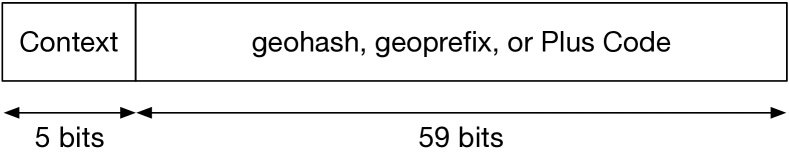
We take the example of LoRa networks to consider the problem of representing geographical locations in identifiers and DNS names. We propose a scheme to define the geo-identifier of a LoRaWAN device in a way that encodes its geographical location. Figure 4 presents its structure with two fields: 5 bits for the Context and 59 bits for encoding geographical coordinates of different forms. The Context gives the information about the type of encoding.
LoRaWAN defines DevEUI, a unique 64 bit identifier in the IEEE EUI-64 [15] configured on a device. In the activation process of the device, it obtains DevAddr, a 32 bit identifier in the current network allocated by the Network Server. We propose to use a geo-identifier as DevEUI, store DevEUI as a DNS name, and provide a lookup service-based DNS service discovery that returns names corresponding to a geographical region.
Then, we can encode a binary string in the geohash variant of base32 giving us a name. For instance, the binary value of 01101 11111 11000 00100 00010 (25 bits) results in the ezs42 geohash composed of 5 characters, the representation having a location error of 2.4 km.
With 59 bits for encoding the latitude and the longitude, a geoprefix or a geohash result in a resolution of a few cm. Table III presents the size of the base32 encoded geohash, the number of bits representing longitude and latitude, and the precision of the decoded value.
Geohashes offer interesting features: i) similar geohashes represent nearby positions and ii) a longer geohash represents a smaller area and shortening it reduces the precision of both its coordinates to represent a larger region.
| geohash | Latitude | Longitude |
|---|---|---|
| dr5r7p4rx6kz | 40.689167 | -74.044444 |
| dr5r7p4 | 40.69 | -74.04 |
| dr5r111 | 40.61 | -74.13 |
Table IV presents a practical example of the prefix property of a geohash. In the table, the second geohash is a prefix of the first one, so it is more precise and is contained in the second one. The second and the third geohash have a common prefix, so they are in the same region (easily computable with the common prefix) but do not overlap.
Plus Codes can be shortened relative to a reference location, which reduces the number of digits to use and we can define the reference location in a given Context. They have similar properties to geohashes and geoprefixes—they represent areas and the size of the area depends on the code length.
We can store a string version of the geohash and Plus Code in DNS as the names of an IoT device and enable some geographical/proximity searches using the geohash.org site or Google Maps (Plus Code required).
The only constraint of using geo-identifiers for DevEUI is the fact that DevEUI does not have the EUI-64 format anymore, which may be an obstacle for some applications. On the other hand, we gain the possibility of linking the device location with its identifier.
V Device Discovery with DNS Queries
In this section, we discuss the issue of how we can query the DNS system to discover some properties of IoT devices and find relevant devices corresponding to those properties. We propose to use the defined semantic identifiers and DNS names to offer support for search and discovery. In constrained environments, providing full-fledged database search functionality may be difficult. Instead, we propose to take advantage of the DNS system as the basic functionality for querying and discovering the semantic properties related to IoT devices.
V-A DNS Service Discovery
DNS-Based Service Discovery (DNS-SD) [16] is a functionality of DNS to discover services in a network. Information about a given service is stored in the DNS database as an SRV record of the form:
¡Instance¿.¡Service¿.¡Domain¿ IN SRV ¡data¿
and gives the target host and the preassigned port at which the service instance can be reached. The TXT record for the same name gives additional information about this instance in a structured form using key/value pairs.
A DNS client can discover the list of available instances of a given service type using a query for a DNS PTR record with a name of the form <Service>.<Domain> which returns a set of zero or more PTR records giving the <Instance> names of the services that match the queried <Service>. Each PTR record is structured as such:
¡Service¿.¡Dom¿ IN PTR ¡Instance¿.¡Service¿.¡Dom¿
The <Instance> portion of the PTR data is a user-friendly name consisting of UTF-8 characters, so rich-text service names and subdomains are allowed and encouraged, for instance:
LoRa temp sensor.Room 7._iot._udp.example.com.
The <Service> portion of the query consists of a pair of DNS labels, following the convention already established for SRV records, for instance, the PTR entry for name _http._tcp.local.:
_http._tcp.local. PTR web-page._http._tcp.local.
advertises a “web-page” accessible over HTTP/TCP.
We propose to use this mechanism for querying DNS to find devices relevant to properties or locations expressed in as our semantic names. For example, the following query:
_dr5r7p4r._iot._udp.iot.org IN PTR
would look for IoT devices near the Statue of Liberty.
V-B Structuring Queries as Subdomains
The DNS system stores resource records in a hierarchical tree in which servers can delegate the management of subdomains. For example, DNS Server A, authoritative for example.fr can delegate the management of the records for data.example.fr to DNS Server B. In a similar way, we can delegate the management of a given geographical region to a specific server whose region is included in the encompassing region of the delegating domain. For instance, if we want to delegate the management of the New York area to a city-managed DNS server, we need to configure a “New York area” subdomain and delegate it.
The in-addr.arpa domain, in charge of reverse DNS lookups already uses this kind of method to delegate the management of an IPv4 address to the owner: when making a reverse DNS query on 1.2.3.4, we query 4.3.2.1.in-addr.arpa that corresponds to the chain of delegations of the 1.in-addr.arpa subdomain for the 1.0.0.0/8 and so on.
We can use a similar method to split semantic names into multiple subdomains to easily delegate some properties or locations to other servers. Here is an example for geo-identifiers: instead of having to encode all possible geo-identifiers under the _iot._udp.iot.org domain, we create the dr._iot._udp.iot.org subdomain and let it handle all areas with the dr geoprefix (encompassing the east coast of the USA). This subdomain can delegate subdomains to other servers if needed. Similarly, the server in charge of the dr prefix (east coast) can delegate the dr5r area (encompassing New-York) to another server (a city managed server for example). Then, the administrator of this server can choose to handle the 7p.5r.dr subdomain, as it represents an area of 600 meters around the Statue of Liberty. As a result, instead of querying dr5r7p._iot._udp.iot.org, we can query for instance 7p.5r.dr._iot._udp.iot.org and let each subdomain administrator choose if she wants to delegate some areas to other servers.
There are several ways to split a given semantic name into multiple subdomains so the user has to know the number of characters in a given subdomain to use it in a query. The number of bytes in each subdomain also influences the kind of queries a user can do. For example, setting characters per subdomain, like in 34.12._iot._udp.iot.org, makes it impossible to query directly for devices with the 123 prefix, so the user has to either query the whole prefix 12._iot._udp.iot.org and then filter the relevant results, or query all 3[0-f].12._iot._udp.iot.org domains ( queries). Thus, we need to choose the subdomain size carefully. We propose three schemes for splitting geo-identifiers: a static subdomain length, a dynamic subdomain length, and multiple subdomain lengths.
Static subdomain length. We set size for all subdomains. In this way, the user can split the geo-identifier in several groups of size (rounded up or down, depending on the preference of a query on the encompassing zone and then filtering, or making multiple sub-queries) without any additional knowledge. The drawback is the lack of flexibility and the arbitrary choice of that may be suitable for a given area but not for another one.
Dynamic subdomain length. Each domain has a TXT record that gives the size of the subdomains related to a given area. For example, 12._iot._udp.iot.org IN TXT "len=3" informs the user that under the 12 subdomain, each subdomain has length , so one can query 345.12._iot._udp.iot.org. This scheme supports the right subdomain length for each region: in a dense area where we need multiple precise subdomain delegations, we can set a small length to obtain precise subdivision and in sparse areas where we do not need small subdivisions (seas, fields), we can use a larger length (3 or 4). The scheme supports multiple subdomain lengths in the same query like in 6.345.12._iot._udp.iot.org as each subdomain can set its size. The drawback is the need for recursively querying different subdomains for their TXT records to know the length of each field before splitting the query the right way.
Multiple subdomain lengths. There are multiple ways to get to a given subdomain, so multiple ways of splitting the geo-identifier are possible and valid. For example, both 345.12._iot._udp.iot.org and 5.34.12._iot._udp.iot.org are valid and point to the same area. In this way, the users do not have to query for TXT records and can split their queries as they want. However, it may be hard to encode all ways of splitting the geo-identifier into subdomains in a resource record.
We can simplify this method with CNAME records, the same way the in-addr.arpa domain handles the delegation of subnetworks with arbitrary size151515https://tools.ietf.org/html/rfc2317 by defining multiple CNAME records. For example, if two different servers need to handle the prefixes 12a and 12b but the 12._iot._udp.iot.org domain only defines subdomains of length , we can insert the following records:
  a NS server.handling.a.12.area
  a0 CNAME 0.a.12._iot._udp.iot.org
  a1 CNAME 1.a.12._iot._udp.iot.org
  a2 CNAME 2.a.12._iot._udp.iot.org
  …
  af CNAME f.a.12._iot._udp.iot.org
We can apply the same approach to all bX.12 records. Once the CNAME records are created, a user querying a2.12._iot._udp.iot.org will be redirected to 2.a.12._iot._udp.iot.org, so she will try to resolve the a.12 part and will receive an NS entry pointing to the server in charge of the 12a area. Therefore, with these records, the user does not have to know how the delegation in the 12 area works, the query does not change from her point of view, but with CNAME and NS records, we can transparently delegate parts of the subdomain. Moreover, this method allows for easy modification of the server in charge of (authoritative for) a.12 because changing the NS entry is easy and the CNAME records remain the same. The method may generate many CNAME entries but they are simple to generate automatically and do not need to change often.
We can use the subdomain splitting for different contexts like for logical localizations. In this particular case, we can easily encode the properties in different subdomains because they are naturally ordered (a room on a given floor in a given building). For example, if the Context for Logical Localization is 2, the position of a device in Building 1 on Floor 5 in Room 56 is as follows (with base32 geohash in the parenthesis):
-
•
Context-2: - (2)
-
•
Building: - (1)
-
•
Floor: - (5)
-
•
Room: - (1s)
So, to get the sensors in this room, we send the following query:
_1s._5._1._2._iot._udp.iot.org IN PTR
V-C Use of AXFR for the Result Set
Another way of obtaining the result set from a DNS server is to use the DNS Zone Transfer Protocol (AXFR) [17] that returns all records in a zone. When a client sends an AXFR query message to an authoritative server, it answers with all resource records stored in the zone. This feature can be used to return the results of a query on subdomains describing a property or a geographical area of the interest. For instance, to get all devices and the corresponding data stored in the zone in 123456, the user can use the following command:
dig @server AXFR 56.34.12._iot._udp.iot.fr
VI Prototype Implementation of Semantic Discovery
We have implemented two prototypes for geo-identifiers of LoRa devices. Their extension to consider other types of semantic names is undergoing. The prototypes for geo-identifiers are available to the public to encourage reproducibility. We show below some examples of their utilization with commands using the dig tool. These prototypes only consider geohashes encoded in the domain name without the use of the Context described in Section III.
The first prototype,161616https://github.com/dsg-unipr/geo-dns which takes advantage of the Node-based dns2 module [18] and the Redis in-memory database,171717https://redis.io allowed us to quickly deploy and test the concepts based on hardcoded data.
The second prototype181818https://github.com/fabrizior/coredns uses the CoreDNS DNS server written in Go.191919https://coredns.io CoreDNS is highly flexible thanks to plugins that perform different functions: DNS, Kubernetes service discovery, Prometheus metrics, rewriting queries, and many more. We have modified the file plugin that enables serving zone data from an RFC 1035-style master file.
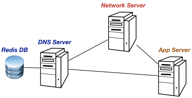
In our prototypes, Applications or Network Servers that want to discover the location of LoRa devices can query a DNS server to find the devices matching some criteria based on their location. In other types of networks, devices themselves can directly query a DNS server.
In a LoRa network with geo-identifiers, when registering a device, the Network or Join Server register several records in the DNS database. First, an SRV record giving the domain and ports where the Network Server managing a given device can be queried. Then, PTR records that allows finding the device based on its geo-identifier or name:
¡name¿._iot._udp.¡Domain¿ IN SRV ¡port¿ ¡domain¿
_¡geo-i¿._iot._udp.¡Domain¿ IN PTR ¡name¿
name being the semantic name like described in Section III. This name of the given domain is unique and describes the properties of the device. geo-i is the geo-identifier of the device encoded in multiple subdomains as described in Section V-B. When an application needs to find all devices in a given area, it can query DNS for all devices in the matching subdomain by sending a query like:
_¡geo-i¿._iot._udp.¡Domain¿ IN PTR,
where geo-i can be split into multiple subdomains if needed.
The DNS server answers with the list of all PTR records in the queried subdomain, and therefore, in the represented area. Each PTR record gives the semantic name of a device in the area. Once the application knows the name of the devices in the area, it can query the DNS server for an SRV record with the different semantic name and get the Network Server managing the devices.
We have implemented this method in our prototypes and both of them can be queried with the dig tool.202020The address 127.0.0.1 used in the following examples should be replaced with the actual IP address of the DNS server. Upon receiving a PTR query for a specific <Service>, the server returns all instances of that service type in the subdomain:
# dig @127.0.0.1 -p 53 _dr._iot._udp -t PTR
;; QUESTION SECTION:
;_dr._iot._udp. IN PTR

;; ANSWER SECTION:
_dr._iot._udp. 100 IN PTR humidity.dr12._iot._udp.
_dr._iot._udp. 100 IN PTR temperature.dr34._iot._udp.
_dr._iot._udp. 100 IN PTR temperature.dr56._iot._udp.
Then, once the application has obtained the semantic name of the device (for example, temperature.dr56), it can query the server for an SRV record with this name, which will contain the domain and ports at which access the device. It can also ask for TXT records to get additional data about the device. For example, still using dig:
# dig @127.0.0.1 -p 53 temperature.dr56._iot._udp -t ALL
;; QUESTION SECTION:
;temperature.dr56._iot._udp. IN ALL

;; ANSWER SECTION:
temperature.dr56._iot._udp. 100 IN SRV 10 20 8080 dr56.unipr.it.
temperature.dr56._iot._udp. 100 IN TXT ”temperature=14”
Finally, when an A query for the <Domain> managing a device is received, the server returns the IP address of the Network Server the LoRa device is associated with. For example, if the following dig command is executed:
# dig @127.0.0.1 -p 53 dr56.unipr.it -t A
;; QUESTION SECTION:
;dr56.unipr.it. IN A
we obtain the following answer:
;; ANSWER SECTION:
dr56.unipr.it. 100 IN A 160.78.28.203
VII DNS as a Source of IoT Data
In the previous sections, we have presented the schemes for encoding device properties in domain names to discover devices by querying the DNS infrastructure. Once the user discovers some relevant devices, she still needs to contact them with different protocols to obtain data or set up data delivery process with the COAP Observe option for instance. We can also take advantage of the DNS infrastructure as a public store for IoT data in a similar way to the Cloud. Many IoT applications store data in the Cloud for further processing and access by clients.
The idea of DNS as a source of IoT data is to use a TXT record associated with a name of an IoT device to store its data so that a large number of users can access the data in DNS instead of getting them directly from the device. As a TXT record linked to a domain is usually already filled with human readable data related to the domain, we can add dynamically created records. Once the IoT data is stored in the TXT record, users will benefit from the DNS caching infrastructure efficient dissemination: recursive resolvers will cache its content and keep the data until the time-to-live (ttl) of the record expires. Then, the recursive resolvers will query the authoritative server to get the new record and the updated data from the device. With this method, the end users do not need to know what kind of a protocol should be used to contact the device, as data are stored in a standard TXT record and no direct contact between the user and the device is required.
VII-A Encoding Data in TXT Records
RFC 6950212121https://tools.ietf.org/html/rfc6950 describes under what conditions an application can use DNS to store data and provides several recommendations and warnings indicated by other RFCs. RFC 1464222222https://tools.ietf.org/html/rfc1464 formalized the <key>=<value> format for storing data in TXT records, so in the case of the example of a temperature sensor, the DNS entry should be <domain> IN <ttl> TXT "temperature=14".
Not all types of data should be placed in DNS: records with a large size can be used by attackers as an amplifier to generate a lot of traffic [19] (this is why .com records are limited to 1460 bytes). Therefore, this solution may not be suitable for all kinds of sensors. For example, a device taking periodic pictures would generate data that should not be put on DNS, instead, the user will have to find a way to contact the device directly, or its Network Server to get the data from a suitable source.
VII-B Updating Data in TXT Records
To keep data in the DNS record updated, there should be a process or an entity that gets the data from the device and updates the corresponding TXT record. For non-constrained devices, an IoT device could update its own record, but for most constrained devices, this kind of operation may be too costly, so another entity can update data. For LoRa networks, all data from the devices go through the Network Server. As this server is not constrained, it can update the TXT record on behalf of the device using, for example, secure Dynamic DNS Update protocol extension [20] and a standard Unix nsupdate command to insert the new values in the zone file of the authoritative DNS server.
Because the data are not updated in real time, it is important to choose a suitable ttl value of the TXT record, so that the data are “marked” as out of date when new values are available. The ttl value must take into account the frequency at which the Network Server retrieves the new data from the device and updates the corresponding DNS record. For example, if the Network Server retrieves the temperature data and dynamically updates TXT records every hour, then the ttl value should be “synchronized” and also set to one hour so that the information stored in caches of local DNS resolvers, which request the data on behalf of local clients, is also up to date.
We can also use the Incremental Transfer mechanism (IXFR)232323https://tools.ietf.org/html/rfc1995 designed to transfer only a modified part of a zone, for example, the updated TXT records with the changed temperature. Each time the zone is dynamically updated by, for example, the Network Server, the serial number of its zone is increased. Therefore, after the initial AXFR transfer, the client should keep record of the Start of Authority (SOA) serial number of the transferred zone. Next, the client can send an IXFR request with the registered version number so that the authoritative name server responds only with the deleted and added resource records since the version known by the IXFR client up to the current version of the zone stored by the authoritative server. For example, to get new data related to the 123456 location, the client can use the following command:
dig @server IXFR=[old-ser] 56.34.12._iot._udp.iot.fr
VIII Conclusion
In this paper, we have proposed a scheme for representing semantic metadata of IoT devices in compact identifiers and DNS names to enable simple discovery and search with standard DNS servers. Our scheme defines a binary identifier as a sequence of bits composed of a Context and several bits of fields encoding semantic properties specific to the Context. The bit string is then encoded as a character string, stored in DNS. In this way, we may take advantage of the DNS system as the basic functionality for querying and discovery of semantic properties related to IoT devices.
We have defined specific Contexts for hierarchical properties as well as logical and geographic locations. For this last part, we have developed two prototypes that manage geo-identifiers in LoRa networks to show that the proposed scheme can take advantage of the standard DNS infrastructure.
Regarding future work, we will thoroughly assess the proposed approach using deployed LoRaWAN devices. Furthermore, we plan to further investigate the idea of DNS as a source of IoT data, with particular attention to the problem of getting data from the devices and updating the TXT records.
Acknowledgments
This work has been partially supported by the French Ministry of Research projects PERSYVAL-Lab under contract ANR-11-LABX-0025-01 and DiNS under contract ANR-19-CE25-0009-01.
References
- [1] C. Jennings, Z. Shelby, and J. Arkko, “IETF Draft - Media Types for Sensor Markup Language,” IETF, draft-jennings-core-senml-10, 2012.
- [2] IPSO, “IPSO Alliance Framework,” http://www.ipso-alliance.org/wp-content/media/draft-ipso-app-framework-04.pdf.
- [3] M. B. Alaya, S. Medjiah, T. Monteil, and K. Drira, “Toward Semantic Interoperability in oneM2M Architecture,” IEEE Commun. Mag., vol. 53, no. 12, pp. 35–41, 2015.
- [4] E. Kovacs et al., “Standards-Based Worldwide Semantic Interoperability for IoT,” IEEE Communications Magazine, vol. 54, no. 12, pp. 40–46, 2016.
- [5] A. Haller et al., “The Modular SSN Ontology: A Joint W3C and OGC Standard Specifying the Semantics of Sensors, Observations, Sampling, and Actuation,” Semantic Web, vol. 10, no. 1, pp. 9–32, 2019.
- [6] D. Pfisterer et al., “SPITFIRE: Toward a Semantic Web of Things,” IEEE Communications Magazine, vol. 49, no. 11, pp. 40–48, 2011.
- [7] O. Novo and M. D. Francesco, “Semantic Interoperability in the IoT: Extending the Web of Things Architecture,” ACM Trans. Internet Things, vol. 1, no. 1, pp. 6:1–6:25, 2020.
- [8] M. Amoretti, O. Alphand, G. Ferrari, F. Rousseau, and A. Duda, “DINAS: A Lightweight and Efficient Distributed Naming Service for All-IP Wireless Sensor Networks,” IEEE Internet of Things Journal, vol. 4, no. 3, pp. 670–684, 2017.
- [9] C. Hesselman et al., “The DNS in IoT: Opportunities, Risks, and Challenges,” IEEE Internet Computing, vol. 24, no. 4, pp. 23–32, 2020.
- [10] P. Brunisholz, F. Rousseau, and A. Duda, “DataTweet for user-centric and geo-centric IoT communications,” in Proc. of the MobiCom Workshop on Experiences in the Design and Implementation of Smart Objects,. ACM Press, 2016, pp. 29–34.
- [11] G. Niemeyer, “Geohash,” 2008. [Online]. Available: http://en.wikipedia.org/wiki/Geohash
- [12] G. M. Morton, A Computer Oriented Geodetic Data Base and a New Technique in File Sequencing. IBM, 1966.
- [13] Google, “Plus Codes: Addresses for Everyone,” 2020. [Online]. Available: https://plus.codes
- [14] ——, “Open Location Code,” 2020. [Online]. Available: https://github.com/google/open-location-code
- [15] IEEE Standards Association, “Guidelines for Use of Extended Unique Identifier (EUI), Organizationally Unique Identifier (OUI), and Company ID (CID),” 2018.
- [16] S. Cheshire and M. Krochmal, “DNS-Based Service Discovery,” 2013. [Online]. Available: https://tools.ietf.org/html/rfc6763
- [17] M. Skwarek, M. Korczyński, W. Mazurczyk, and A. Duda, “Characterizing Vulnerability of DNS AXFR Transfers with Global-Scale Scanning,” in Proc. of the IEEE Security and Privacy Workshops, 2019.
- [18] L. Song, “dns2 - A DNS Server and Client Implementation,” 2020. [Online]. Available: https://github.com/song940/node-dns
- [19] C. Rossow, “Amplification Hell: Revisiting Network Protocols for DDoS Abuse,” in In Proc. of NDSS, 2014.
- [20] M. Korczyński, M. Król, and M. van Eeten, “Zone Poisoning: The How and Where of Non-Secure DNS Dynamic Updates,” in Proc. of IMC, 2016, p. 271–278.